Illinois | Northern Illinois
Kishwaukee River
Hickory Bills Canoe Launch to Distillery Road Conservation Area
Check current paddling conditions for this Kishwaukee River route, including water level, recent gauge trend, weather, and route details.
Route snapshot
Loading the route snapshot. This usually takes a few seconds.
Today
Get the answer fast, then scan the route.
Start with the verdict, current conditions, route plan, and quick facts before you commit to the drive.
Today's conditions
Gauge
Recent trend
Checking preferred range.
Checking trend.
Gauge source
-- Checking timestampMN DNR provides the current paddling level here, but not chart-ready recent samples.
Weather
Best window today
Checking weather.
Today by hour
Short-route forecast
Checking the next several hours.
Quick facts
Plan
Dial in the shuttle, distance, and access.
Use this section once the route looks viable and you need to turn it into an actual trip plan.
Access plan
Access, shuttle, and map
Launch at Hickory Bills Canoe Launch in Belvidere and take out at the Distillery Road Conservation Area canoe launch. This avoids the upstream Belvidere Dam portage and uses the Belvidere USGS gauge that local Kishwaukee access managers point paddlers toward.
Put-in
Hickory Bills Canoe Launch Open mapIllinois public-water access rules are stricter and more confusing than many nearby states. Use the established public launches and do not assume permission to land on private banks along the route.
Take-out
Distillery Road Conservation Area canoe launch Open mapThe BCCD/Openlands water-trail map identifies Hickory Bills and Distillery Road as established launch sites, but Distillery Road is a conservation area with posted hours and hunting-season closures.
Pulling access map tiles. Usually under 5 seconds.
Access caveats
- Illinois public-water access rules are stricter and more confusing than many nearby states. Use the established public launches and do not assume permission to land on private banks along the route.
- The BCCD/Openlands water-trail map identifies Hickory Bills and Distillery Road as established launch sites, but Distillery Road is a conservation area with posted hours and hunting-season closures.
- Inspect the Distillery Road take-out before launching if you have not used it before; the shoreline is natural rather than a large concrete ramp.
Watch for
- Shallow riffles and gravel-bar scraping when the Belvidere gauge is 200 cfs or lower.
- Very high, dirty, pushier water when the gauge rises above 600 cfs, especially after storms.
- Strainers, wood, blind bends, wind on open bends, and changing natural-bank landings.
- Wastewater-treatment-plant discharge context near Belvidere; avoid paddling after heavy rain or when water quality looks poor.
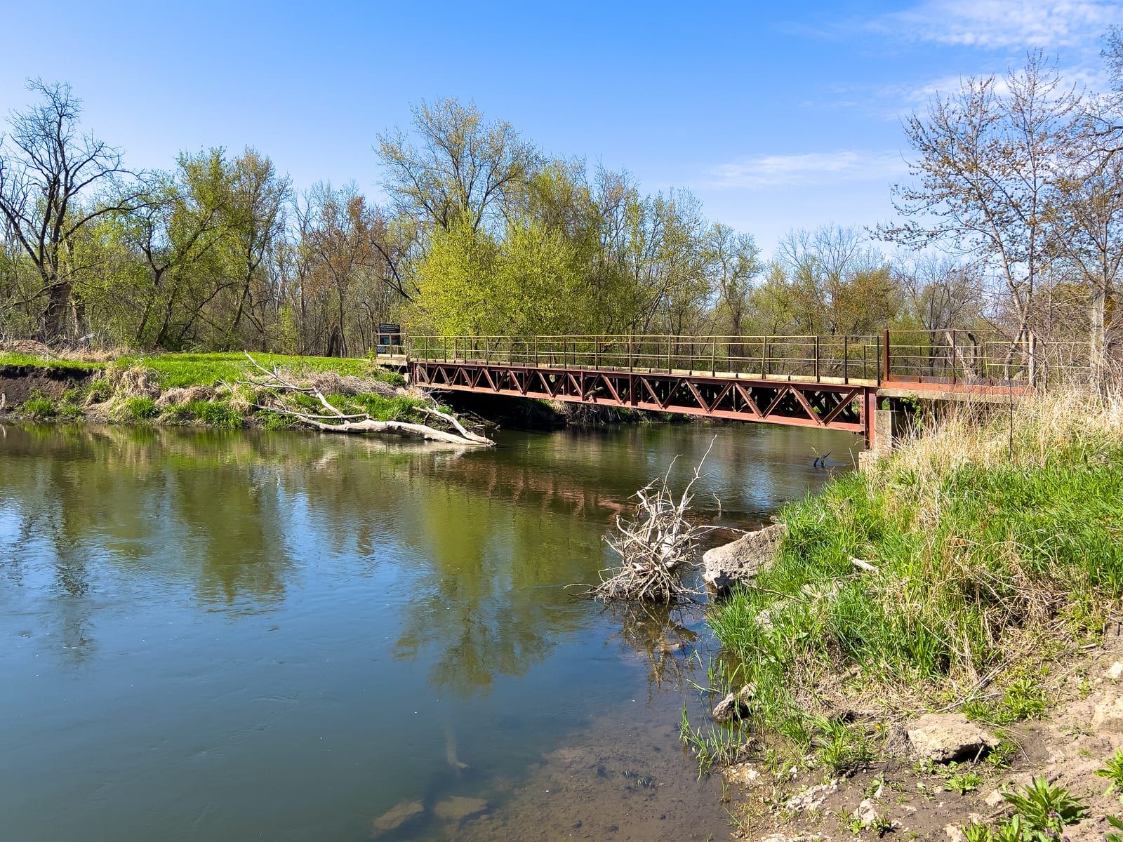
Route gallery
See this route on the water
Photos help show what the access looks like and what the route actually feels like on the water.
Sources
Check the data behind today's call.
Use this section when the page shows stale data, limited confidence, or a call you want to verify before driving.
Why this score Today's data confidence is checking
Data confidence mostly comes down to three things: how direct the gauge is, how clear the range is, and how fresh the data is.
- Checking data confidence notes.
- Checking data confidence cautions.
Outlook Tomorrow and weekend
This is a cautious early look. If the data is too thin, we leave it out.
Waiting on forecast.
Waiting on forecast.
Data behind the score Gauge, thresholds, and timing
These are the live readings and threshold notes behind today's score.
| Gauge site | Kishwaukee River at Belvidere, IL |
| Discharge | Checking |
| Gauge height | Checking |
| 24h trend | Checking |
| 24h change | Checking |
| Current band | Checking |
| Rain last 24h | Checking |
| Rain last 72h | Checking |
| Air temp | Checking |
| Water temp | Checking |
| Wind | Checking |
| Gusts | Checking |
| Rain timing | Checking |
| Target band | 201 cfs to 600 cfs |
| Low threshold | 200 cfs |
| High threshold | 600 cfs |
| Data confidence behind the range | Local route guidance |
| Gauge observed | Checking |
| Paddle Today updated | Checking |
| Main source behind this score | Wisconsin River Trips Belvidere-gauge navigability estimates for the Kishwaukee River |
| Gauge source | Checking |
| Weather source | Checking |
| Rainfall source | Checking |
Notes What to know before you go
These notes cover the access details, route quirks, and source caveats most likely to matter once you get there.
- Water-trail segment 4.35 to 4.7 miles
The BCCD/Openlands Kishwaukee water-trail map lists Hickory Bills Island to Distillery Road as a 4.35-mile trip, while Wisconsin River Trips rounds the Hickory Bills-to-Distillery segment to 4.7 miles.
- Public access Belvidere Park District and BCCD launches
The water-trail map identifies Hickory Bills Island as a Belvidere Park District launch and Distillery Road as a Boone County Conservation District launch with public access amenities.
- Take-out authority Distillery Road canoe launch
Boone County Conservation District lists Distillery Road Conservation Area with a canoe launch, parking, portable restroom, picnic tables, and public access to fishing on the Kishwaukee River.
- Gauge tie USGS 05438500 at Belvidere
BCCD tells paddlers using Distillery Road or County Line East to check real-time data from the Belvidere stream gage for current water level and flow conditions.
- Flow bands 201-600 cfs target, 600+ very high
Wisconsin River Trips estimates 0-200 cfs as low but mostly navigable, 201-400 cfs as average/good, 401-600 cfs as high but likely navigable, 601-1000 cfs as very high and less attractive, and 1001+ cfs as possible flood level.
- Closure check Lower Kishwaukee open effective 2026-04-24
IDNR River Closures currently lists the lower Kishwaukee closure reach downstream of Cherry Valley as open. This Hickory Bills-to-Distillery route is upstream of that notice, but closure checks remain important for Kishwaukee trips.
Verify it yourself Check the source links
Use these links to double-check the gauge, route details, and access notes before you head out.
Paddler reports
Recent notes from paddlers
A few quick notes from people who were on this route recently.
Reports
Photos, paddler notes, and updates.
See what others have shared, then add a condition report, upload photos, or flag anything that needs fixing.
Share your trip
Keep exploring
More routes to check next
Compare another stretch on this river, or jump to nearby options before you pick a plan.
More in Illinois
All 2 routesNearby routes by distance
Quick answers
Kishwaukee River paddling FAQ
What water level is good for paddling Kishwaukee River?
Paddle Today watches Kishwaukee River at Belvidere, IL and treats 201 cfs to 600 cfs as the target band for this route, with weather and recent trend included in the final score.
Where does this Kishwaukee River route start and end?
This route starts at Hickory Bills Canoe Launch and ends at Distillery Road Conservation Area canoe launch, about About 4.4 mi on the water.
Is this Kishwaukee River route good for beginners?
This is listed as an easy route, but conditions still matter. Check today's score, water level, weather, and access notes before you go.
Flag a change
See something outdated?
Access, hazards, wood, and shuttle details change. Send a quick correction if something looks off.