See all 6 routes on Clinton River
Michigan | Southeast Michigan
Clinton River
MacArthur Park to Harley Ensign
Check current paddling conditions for this Clinton River route, including water level, recent gauge trend, weather, and route details.
Route snapshot
Loading the route snapshot. This usually takes a few seconds.
Today
Get the answer fast, then scan the route.
Start with the verdict, current conditions, route plan, and quick facts before you commit to the drive.
Today's conditions
Gauge
Recent trend
Checking preferred range.
Checking trend.
Gauge source
-- Checking timestampMN DNR provides the current paddling level here, but not chart-ready recent samples.
Weather
Best window today
Checking weather.
Today by hour
Short-route forecast
Checking the next several hours.
Quick facts
Plan
Dial in the shuttle, distance, and access.
Use this section once the route looks viable and you need to turn it into an actual trip plan.
Access plan
Access, shuttle, and map
Launch at the Neil Dempsey launch in MacArthur Park and follow the lower Clinton River to Harley Ensign at the Lake St. Clair end of the water trail. Use the Sterling Heights USGS stage as a warning check, then make a separate wind, waves, boat-traffic, and water-quality decision for the mouth section.
Put-in
Neil Dempsey Launch at MacArthur Park Open mapCRWC maps Neil Dempsey at MacArthur Park and Harley Ensign (DNR) as Clinton River Water Trail access points with coordinates and a 7.2-mile access spacing.
Take-out
Harley Ensign DNR launch Open mapHarley Ensign is at the Lake St. Clair end of the route, so inspect the take-out and do not let river current push the group into open-water exposure without an intentional plan.
Pulling access map tiles. Usually under 5 seconds.
Access caveats
- CRWC maps Neil Dempsey at MacArthur Park and Harley Ensign (DNR) as Clinton River Water Trail access points with coordinates and a 7.2-mile access spacing.
- Harley Ensign is at the Lake St. Clair end of the route, so inspect the take-out and do not let river current push the group into open-water exposure without an intentional plan.
- Stay with public launches and avoid private banks; CRWC specifically tells paddlers to plan exits at public access points.
Watch for
- Low-water scraping or slow travel when the Sterling Heights gauge is at or below the CRWC 8 ft low-water warning.
- High, fast water, strainers, and woody debris when the gauge approaches or exceeds the 10 ft high-water warning, especially after rain.
- Urban stormwater and possible sewage-overflow water-quality concerns after high-flow events.
- Motorboat traffic, wind, waves, marina or channel traffic, and open-water consequences near Lake St. Clair.
- Do not continue onto Lake St. Clair unless your group has the weather window, craft, navigation, and rescue plan for open-water paddling.
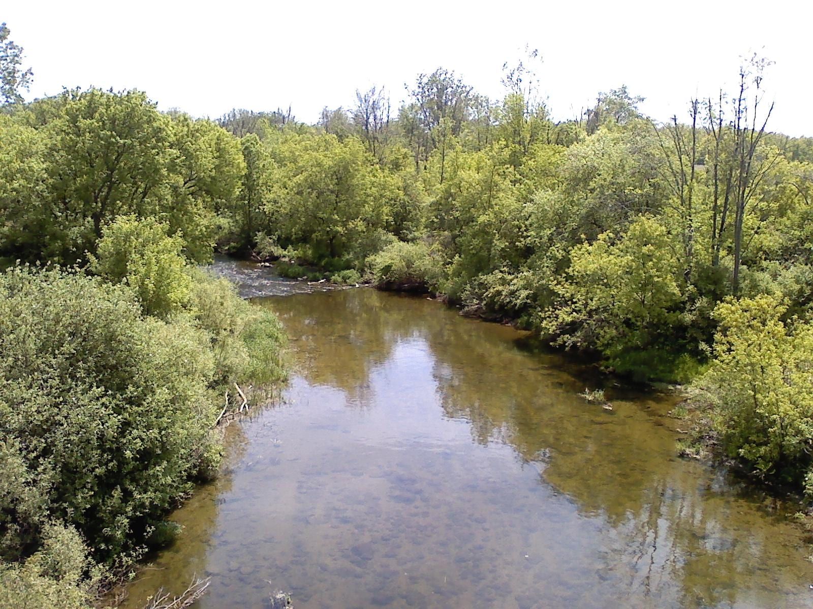
Route gallery
See this route on the water
Photos help show what the access looks like and what the route actually feels like on the water.
Sources
Check the data behind today's call.
Use this section when the page shows stale data, limited confidence, or a call you want to verify before driving.
Why this score Today's data confidence is checking
Data confidence mostly comes down to three things: how direct the gauge is, how clear the range is, and how fresh the data is.
- Checking data confidence notes.
- Checking data confidence cautions.
Outlook Tomorrow and weekend
This is a cautious early look. If the data is too thin, we leave it out.
Waiting on forecast.
Waiting on forecast.
Data behind the score Gauge, thresholds, and timing
These are the live readings and threshold notes behind today's score.
| Gauge site | Clinton River at Sterling Heights, MI |
| Gauge height | Checking |
| Discharge | Checking |
| 24h trend | Checking |
| 24h change | Checking |
| Current band | Checking |
| Rain last 24h | Checking |
| Rain last 72h | Checking |
| Air temp | Checking |
| Water temp | Checking |
| Wind | Checking |
| Gusts | Checking |
| Rain timing | Checking |
| Target band | 8.00 ft to 10.00 ft |
| Low threshold | 8.00 ft |
| High threshold | 10.00 ft |
| Data confidence behind the range | Official data source |
| Gauge observed | Checking |
| Paddle Today updated | Checking |
| Main source behind this score | Clinton River Watershed Council Sterling Heights gauge warnings |
| Gauge source | Checking |
| Weather source | Checking |
| Rainfall source | Checking |
Notes What to know before you go
These notes cover the access details, route quirks, and source caveats most likely to matter once you get there.
- Access map Neil Dempsey Launch RM 7.2 to Harley Ensign RM 0.0
The 2024 CRWC water-trail map lists Neil Dempsey at MacArthur Park and Harley Ensign (DNR) as launch sites, with 7.2 miles from Neil Dempsey to Harley Ensign at the river mouth.
- Endpoint coordinates 42.597338, -82.871104 to 42.593327, -82.774834
The 2024 CRWC water-trail map table gives coordinates for Neil Dempsey at MacArthur Park and Harley Ensign (DNR).
- Water-trail assets MacArthur Park and Harley Ensign
Michigan Water Trails lists MacArthur Park and Harley Ensign as Clinton River Water Trail access assets.
- Lower-river character Slow-moving lower Clinton to Lake St. Clair
CRWC describes the lower Clinton as slow-moving waters through forested riverbanks and parks before emptying into Lake St. Clair, while warning that the river can still run high and carry woody debris after rain.
- Gauge warnings 8.0 ft low warning / 10.0 ft high warning
CRWC bases water-level warnings on the USGS Sterling Heights gauge and publishes a low-water warning at 8 ft and high-water warning at 10 ft. The app uses this as a conservative proxy warning window for the downstream mouth reach.
- Launch context Macomb County launch list
Macomb County paddling guidance identifies MacArthur Park and Harley Ensign Memorial among county-area kayak, canoe, and paddleboard launch locations.
Verify it yourself Check the source links
Use these links to double-check the gauge, route details, and access notes before you head out.
Paddler reports
Recent notes from paddlers
A few quick notes from people who were on this route recently.
Reports
Photos, paddler notes, and updates.
See what others have shared, then add a condition report, upload photos, or flag anything that needs fixing.
Share your trip
Keep exploring
More routes to check next
Compare another stretch on this river, or jump to nearby options before you pick a plan.
Quick answers
Clinton River paddling FAQ
What water level is good for paddling Clinton River?
Paddle Today watches Clinton River at Sterling Heights, MI and treats 8.00 ft to 10.00 ft as the target band for this route, with weather and recent trend included in the final score.
Where does this Clinton River route start and end?
This route starts at Neil Dempsey Launch at MacArthur Park and ends at Harley Ensign DNR launch, about About 7.2 mi on the water.
Is this Clinton River route good for beginners?
This is listed as a moderate route. Expect more planning than an easy float, and use the live score, route notes, and source links before committing.
Flag a change
See something outdated?
Access, hazards, wood, and shuttle details change. Send a quick correction if something looks off.