See all 3 routes on Eleven Point River
Missouri | Missouri Ozarks
Eleven Point River
Turner Mill South River Access to Whitten River Access
Check current paddling conditions for this Eleven Point River route, including water level, recent gauge trend, weather, and route details.
Route snapshot
Loading the route snapshot. This usually takes a few seconds.
Today
Get the answer fast, then scan the route.
Start with the verdict, current conditions, route plan, and quick facts before you commit to the drive.
Today's conditions
Gauge
Recent trend
Checking preferred range.
Checking trend.
Gauge source
-- Checking timestampMN DNR provides the current paddling level here, but not chart-ready recent samples.
Weather
Best window today
Checking weather.
Today by hour
Short-route forecast
Checking the next several hours.
Quick facts
Plan
Dial in the shuttle, distance, and access.
Use this section once the route looks viable and you need to turn it into an actual trip plan.
Access plan
Access, shuttle, and map
Launch at Turner Mill South and take out at Whitten for the spring-fed Eleven Point link above the existing Whitten-to-Riverton route. Use the Bardley USGS gauge as a conservative low-water check, then make a same-day visual call at the launch.
Put-in
Turner Mill South River Access Open mapTurner Mill South and Whitten are official Forest Service river accesses with published coordinates, but access roads are rural and conditions can change after storms.
Take-out
Whitten River Access Open mapThe Forest Service river-mile notes imply about 6.1 miles from Turner Mill to Whitten, while MoHERP exact-trip evidence rounds Turner Mill to Whitten to 8.0 miles. Plan time conservatively.
Pulling access map tiles. Usually under 5 seconds.
Access caveats
- Turner Mill South and Whitten are official Forest Service river accesses with published coordinates, but access roads are rural and conditions can change after storms.
- The Forest Service river-mile notes imply about 6.1 miles from Turner Mill to Whitten, while MoHERP exact-trip evidence rounds Turner Mill to Whitten to 8.0 miles. Plan time conservatively.
- The Eleven Point corridor includes private lands under scenic easement. Do not assume banks away from public accesses, designated float camps, or legal gravel-bar stops are public.
Watch for
- Shallow shoals and occasional dragging when the Bardley gauge falls near the 300 cfs floor.
- Cold spring-fed water, rapid rises after rain, fresh wood, blind bends, and remote-feeling gaps between accesses.
- Motorized users are allowed on this part of the National Wild and Scenic River under the 25 hp limit.
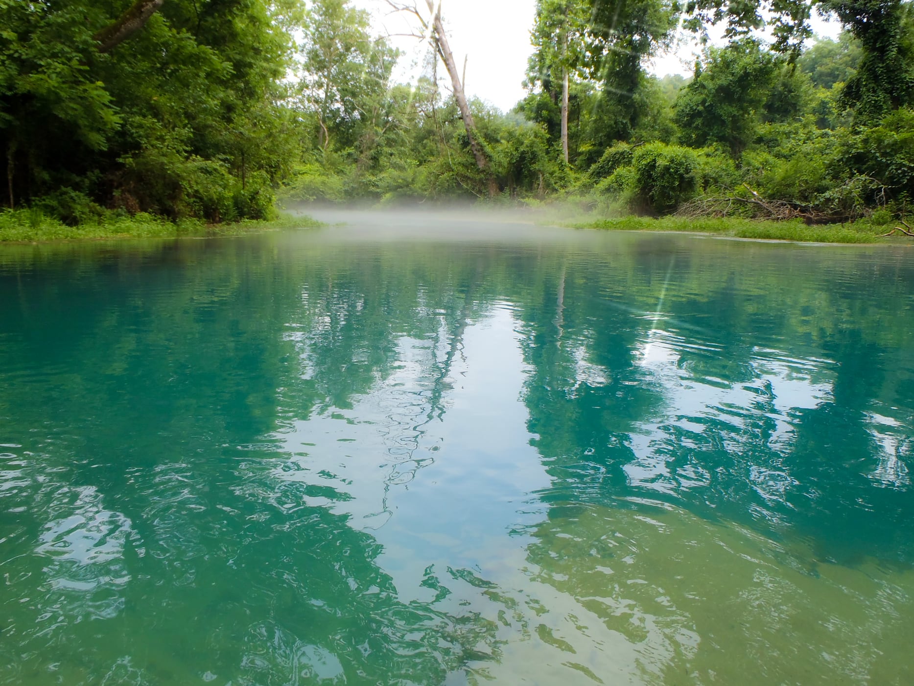
Route gallery
See this route on the water
Photos help show what the access looks like and what the route actually feels like on the water.
Sources
Check the data behind today's call.
Use this section when the page shows stale data, limited confidence, or a call you want to verify before driving.
Why this score Today's data confidence is checking
Data confidence mostly comes down to three things: how direct the gauge is, how clear the range is, and how fresh the data is.
- Checking data confidence notes.
- Checking data confidence cautions.
Outlook Tomorrow and weekend
This is a cautious early look. If the data is too thin, we leave it out.
Waiting on forecast.
Waiting on forecast.
Data behind the score Gauge, thresholds, and timing
These are the live readings and threshold notes behind today's score.
| Gauge site | Eleven Point River near Bardley, MO |
| Discharge | Checking |
| Gauge height | Checking |
| 24h trend | Checking |
| 24h change | Checking |
| Current band | Checking |
| Rain last 24h | Checking |
| Rain last 72h | Checking |
| Air temp | Checking |
| Water temp | Checking |
| Wind | Checking |
| Gusts | Checking |
| Rain timing | Checking |
| Ideal range | Needs paddler reports |
| Known low-water floor | 300 cfs |
| High threshold | Not calibrated yet |
| Data confidence behind the range | Local route guidance |
| Gauge observed | Checking |
| Paddle Today updated | Checking |
| Main source behind this score | Rivers.MOHERP Bardley gauge rating and Turner Mill-to-Whitten trip evidence |
| Gauge source | Checking |
| Weather source | Checking |
| Rainfall source | Checking |
Notes What to know before you go
These notes cover the access details, route quirks, and source caveats most likely to matter once you get there.
- Official route shape Turner Mill South to Whitten
The Forest Service says Turner Mill South is 4.9 miles below Greer Crossing and that Whitten is the next access downriver. Its river-mile notes place Turner Mill near mile 21.5 and Whitten at mile 27.6.
- Public put-in Turner Mill South River Access
The Forest Service lists Turner Mill South as open, on the right bank, with a rustic day-use area, limited campsites, a single-lane concrete boat launch, toilet facilities, parking for 12 vehicles, and coordinates 36.76456, -91.26653037.
- Public take-out Whitten River Access
The Forest Service lists Whitten as open, on the right bank, with a vault toilet, single-lane concrete boat ramp, parking for vehicles with trailers, and coordinates 36.732356, -91.214837.
- Direct gauge USGS 07071500
USGS operates Eleven Point River near Bardley, MO, downstream in the same lower Eleven Point corridor already used by the existing Whitten-to-Riverton V2 route.
- Low-water floor 300 cfs minimum-only
Rivers.MOHERP rates the Bardley gauge Good beginning at 300 cfs and includes Turner Mill-to-Whitten trip evidence marked Good at 797 cfs.
- Route character Spring-fed trout reach
MDC says Greer Spring transforms the river into a coldwater fishery and that the Turner Mill-to-Riverton reach remains cold White Ribbon Trout Area water; the Forest Service notes the river is shared by motorized and nonmotorized users.
Verify it yourself Check the source links
Use these links to double-check the gauge, route details, and access notes before you head out.
Paddler reports
Recent notes from paddlers
A few quick notes from people who were on this route recently.
Reports
Photos, paddler notes, and updates.
See what others have shared, then add a condition report, upload photos, or flag anything that needs fixing.
Share your trip
Keep exploring
More routes to check next
Compare another stretch on this river, or jump to nearby options before you pick a plan.
Quick answers
Eleven Point River paddling FAQ
What water level is good for paddling Eleven Point River?
Paddle Today watches Eleven Point River near Bardley, MO and uses 300 cfs as the conservative low-water floor for this route. The ideal range still needs more paddler reports.
Where does this Eleven Point River route start and end?
This route starts at Turner Mill South River Access and ends at Whitten River Access, about About 6.1 mi by Forest Service river miles on the water.
Is this Eleven Point River route good for beginners?
This is listed as an easy route, but conditions still matter. Check today's score, water level, weather, and access notes before you go.
Flag a change
See something outdated?
Access, hazards, wood, and shuttle details change. Send a quick correction if something looks off.