See all 2 routes on Gasconade River
Missouri | Central Missouri
Gasconade River
Pointers Creek Access to Cooper Hill Conservation Area
Check current paddling conditions for this Gasconade River route, including water level, recent gauge trend, weather, and route details.
Route snapshot
Loading the route snapshot. This usually takes a few seconds.
Today
Get the answer fast, then scan the route.
Start with the verdict, current conditions, route plan, and quick facts before you commit to the drive.
Today's conditions
Gauge
Recent trend
Checking preferred range.
Checking trend.
Gauge source
-- Checking timestampMN DNR provides the current paddling level here, but not chart-ready recent samples.
Weather
Best window today
Checking weather.
Today by hour
Short-route forecast
Checking the next several hours.
Quick facts
Plan
Dial in the shuttle, distance, and access.
Use this section once the route looks viable and you need to turn it into an actual trip plan.
Access plan
Access, shuttle, and map
Launch at MDC Pointers Creek Access and take out at Cooper Hill Conservation Area for a short lower Gasconade day. Use the Rich Fountain gauge as a conservative low-water check rather than a full preferred-range recommendation.
Put-in
Pointers Creek Access Open mapPointers Creek is an MDC public access with Gasconade River boat-ramp context, but posted signs and area maps control exact use.
Take-out
Cooper Hill Conservation Area hand launch Open mapCooper Hill is a hand-launch access. MDC says floaters can access the river from the parking lot and CR 821, but there is no trailered-boat access.
Pulling access map tiles. Usually under 5 seconds.
Access caveats
- Pointers Creek is an MDC public access with Gasconade River boat-ramp context, but posted signs and area maps control exact use.
- Cooper Hill is a hand-launch access. MDC says floaters can access the river from the parking lot and CR 821, but there is no trailered-boat access.
- MDC notes that Route RA to Pointers Creek is impassable when Pointers Creek is at flood stage; inspect the put-in road and river conditions before committing.
- The Cooper Hill coordinate is a practical conservation-area/access anchor paired with MDC hand-launch confirmation. Follow on-site signs for the exact carry, parking, and any temporary restrictions.
Watch for
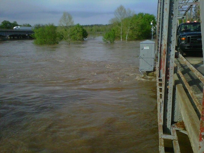
- Dragging, shallow riffles, and slow pools when the Rich Fountain gauge is near or below the 1,100 cfs floor.
- High or rising water after rain, floating wood, muddy current, island splits, strainers on bends, and harder hand-launch landings.
- Motorboats, anglers, gravel bars, private banks, and open pools where wind can slow the trip.
- Private land away from public accesses and lawful gravel-bar stops; do not assume banks are public picnic or camping areas.
Route gallery
See this route on the water
Photos help show what the access looks like and what the route actually feels like on the water.
Sources
Check the data behind today's call.
Use this section when the page shows stale data, limited confidence, or a call you want to verify before driving.
Why this score Today's data confidence is checking
Data confidence mostly comes down to three things: how direct the gauge is, how clear the range is, and how fresh the data is.
- Checking data confidence notes.
- Checking data confidence cautions.
Outlook Tomorrow and weekend
This is a cautious early look. If the data is too thin, we leave it out.
Waiting on forecast.
Waiting on forecast.
Data behind the score Gauge, thresholds, and timing
These are the live readings and threshold notes behind today's score.
| Gauge site | Gasconade River near Rich Fountain, MO |
| Discharge | Checking |
| Gauge height | Checking |
| 24h trend | Checking |
| 24h change | Checking |
| Current band | Checking |
| Rain last 24h | Checking |
| Rain last 72h | Checking |
| Air temp | Checking |
| Water temp | Checking |
| Wind | Checking |
| Gusts | Checking |
| Rain timing | Checking |
| Ideal range | Needs paddler reports |
| Known low-water floor | 1,100 cfs |
| High threshold | Not calibrated yet |
| Data confidence behind the range | Local route guidance |
| Gauge observed | Checking |
| Paddle Today updated | Checking |
| Main source behind this score | Rivers.MOHERP Rich Fountain gauge bands for the Gasconade River |
| Gauge source | Checking |
| Weather source | Checking |
| Rainfall source | Checking |
Notes What to know before you go
These notes cover the access details, route quirks, and source caveats most likely to matter once you get there.
- Public put-in MDC Pointers Creek Access
MDC confirms Pointers Creek Access on the Gasconade River, with directions, area rules, boat-use rules, camping, fishing, and photo documentation of the boat ramp.
- Public take-out Cooper Hill Conservation Area hand launch
MDC says Cooper Hill includes Gasconade River access and that boats are hand-launched after a short walk from the parking area; a separate MDC feature says floaters can access the river from the parking lot and CR 821, but there is no trailered-boat access.
- River-mile support About 5.8 river miles
Missouri Float Trips / MDC-reprint mile notes place Pointers Creek Access at river mile 210.8 and Third Creek / Cooper Hill Access at river mile 216.6.
- Live direct gauge USGS 06934000
USGS operates Gasconade River near Rich Fountain, MO. The official legacy current-conditions page showed 1,640 cfs and 3.36 ft at 2026-05-31 10:30 CDT during review.
- Low-water floor 1,100 cfs minimum-only
Rivers.MOHERP Rich Fountain gauge bands put the start of Low near 1,074 cfs and the start of Good near 1,994 cfs. The app uses a rounded 1,100 cfs low-water floor and does not infer an ideal range.
- High-water caution No numeric cutoff claimed
MoHERP labels higher Rich Fountain levels as High and Flood with strong caution language, but exact-route high-water calibration is missing. Treat high or rising water as unsuitable for casual trips.
Verify it yourself Check the source links
Use these links to double-check the gauge, route details, and access notes before you head out.
Paddler reports
Recent notes from paddlers
A few quick notes from people who were on this route recently.
Reports
Photos, paddler notes, and updates.
See what others have shared, then add a condition report, upload photos, or flag anything that needs fixing.
Share your trip
Keep exploring
More routes to check next
Compare another stretch on this river, or jump to nearby options before you pick a plan.
Quick answers
Gasconade River paddling FAQ
What water level is good for paddling Gasconade River?
Paddle Today watches Gasconade River near Rich Fountain, MO and uses 1,100 cfs as the conservative low-water floor for this route. The ideal range still needs more paddler reports.
Where does this Gasconade River route start and end?
This route starts at Pointers Creek Access and ends at Cooper Hill Conservation Area hand launch, about About 5.8 mi on the water.
Is this Gasconade River route good for beginners?
This is listed as an easy route, but conditions still matter. Check today's score, water level, weather, and access notes before you go.
Flag a change
See something outdated?
Access, hazards, wood, and shuttle details change. Send a quick correction if something looks off.