Arkansas | Ouachita Mountains
Cossatot River
Ed Banks Access to Highway 278 Access
Check current paddling conditions for this Cossatot River route, including water level, recent gauge trend, weather, and route details.
Route snapshot
Loading the route snapshot. This usually takes a few seconds.
Today
Get the answer fast, then scan the route.
Start with the verdict, current conditions, route plan, and quick facts before you commit to the drive.
Today's conditions
Gauge
Recent trend
Checking preferred range.
Checking trend.
Gauge source
-- Checking timestampMN DNR provides the current paddling level here, but not chart-ready recent samples.
Weather
Best window today
Checking weather.
Today by hour
Short-route forecast
Checking the next several hours.
Quick facts
Plan
Dial in the shuttle, distance, and access.
Use this section once the route looks viable and you need to turn it into an actual trip plan.
Access plan
Access, shuttle, and map
Launch at Ed Banks Access and take out at the Highway 278 access for the Cossatot Falls Section. This is not a casual float: use the USGS Vandervoort / Hwy 246 stage as a same-day decision point and skip the run when the river is below the rocky floor, above the expert cutoff, rising fast, or outside the group skill set.
Put-in
Ed Banks Access / low-water bridge Open mapEd Banks and the interior access roads are rough, remote, and subject to rain, flood, low-water-bridge, and timber-hauling conditions. Do not assume low-clearance vehicles can reach the launch after wet weather.
Take-out
Highway 278 Access / Cossatot State Park corridor Open mapThe Highway 278 take-out is the required exit for this route. Confirm the landing, parking, and route back to the vehicle before launching.
Pulling access map tiles. Usually under 5 seconds.
Access caveats
- Ed Banks and the interior access roads are rough, remote, and subject to rain, flood, low-water-bridge, and timber-hauling conditions. Do not assume low-clearance vehicles can reach the launch after wet weather.
- The Highway 278 take-out is the required exit for this route. Confirm the landing, parking, and route back to the vehicle before launching.
- Arkansas State Parks warns not to drive across low-water bridges during high water and prohibits parking on bridges.
- Endpoint coordinates are practical access-area anchors from public map and park/natural-area records, not survey-grade launch points. Make a same-day visual access check.
Watch for
- Class III-IV+ rapids, ledge holes, steep drops, pin rocks, sieves, undercuts, hydraulics, and the six-drop Cossatot Falls sequence.
- The Esses, Cossatot Falls, Deer Camp Rapid, Devil Hollow Rapid, Devil Hollow Falls, and Sandbar Bridge low-clearance/hydraulic hazards.
- Low water below about 3.3 ft at the Hwy 246 / Vandervoort gauge, when the route becomes rocky, technical, and boat-damaging.
- High water around 5.4 ft and above, when Arkansas State Parks describes high/expert conditions and American Whitewater notes large holes and merged drops.
- Fast rain rises, tributary inflow below the gauge, fresh wood, cold-water swims, limited cell service, remote rescue exposure, and no-solo consequences.
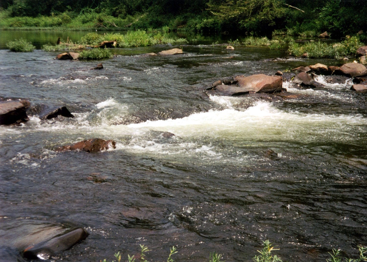
Route gallery
See this route on the water
Photos help show what the access looks like and what the route actually feels like on the water.
Sources
Check the data behind today's call.
Use this section when the page shows stale data, limited confidence, or a call you want to verify before driving.
Why this score Today's data confidence is checking
Data confidence mostly comes down to three things: how direct the gauge is, how clear the range is, and how fresh the data is.
- Checking data confidence notes.
- Checking data confidence cautions.
Outlook Tomorrow and weekend
This is a cautious early look. If the data is too thin, we leave it out.
Waiting on forecast.
Waiting on forecast.
Data behind the score Gauge, thresholds, and timing
These are the live readings and threshold notes behind today's score.
| Gauge site | Cossatot River near Vandervoort, AR |
| Gauge height | Checking |
| Discharge | Checking |
| 24h trend | Checking |
| 24h change | Checking |
| Current band | Checking |
| Rain last 24h | Checking |
| Rain last 72h | Checking |
| Air temp | Checking |
| Water temp | Checking |
| Wind | Checking |
| Gusts | Checking |
| Rain timing | Checking |
| Target band | 3.80 ft to 4.80 ft |
| Low threshold | 3.30 ft |
| High threshold | 5.40 ft |
| Data confidence behind the range | Official and local sources |
| Gauge observed | Checking |
| Paddle Today updated | Checking |
| Main source behind this score | Arkansas State Parks Cossatot River floater stage table and American Whitewater Falls Section reach |
| Gauge source | Checking |
| Weather source | Checking |
| Rainfall source | Checking |
Notes What to know before you go
These notes cover the access details, route quirks, and source caveats most likely to matter once you get there.
- Official route shape Ed Banks low-water bridge to U.S. 278, about 6 miles
Arkansas State Parks says the Cossatot is a 6-mile float from the Ed Banks low-water bridge to the U.S. 278 take-out, with the park corridor running from Highway 246 to U.S. 278.
- Direct live gauge USGS 07340300
USGS Cossatot River near Vandervoort showed same-day May 31, 2026 data during review, including 92.5 cfs and 2.79 ft at 16:30 CDT.
- Stage model 3.3 / 3.8-4.8 / 5.4 ft
Arkansas State Parks floater guidance lists 3.6-3.3 ft as lower levels, 4.0-3.8 ft as traditional normal levels, 4.2 ft as normal with routes in all six falls rapids, 4.5-4.8 ft for strong intermediates with those who know the river, and 5.4 ft and up as high to very high expert water. Paddle Today uses 5.4 ft as the conservative upper cutoff.
- Whitewater reach match 6.4 mi II-IV Falls Section
American Whitewater identifies Ed Banks Road to Highway 278/4 as the Cossatot Falls Section, rates it II-IV, ties it to the Cossatot River near Vandervoort gauge, and lists the major rapids and access directions.
- Access coordinates Ed Banks 34.33975, -94.25069; Highway 278 access 34.29388, -94.17704
Mapcarta/OpenStreetMap places Ed Banks Access as an Arkansas park access parking area, and Arkansas Natural Heritage Commission records place the developed Cossatot State Park / Highway 278 access corridor at 34.29388, -94.17704. Treat both as practical access-area anchors, not survey-grade ramp points.
- Safety posture Not for beginners; no solo runs
Arkansas State Parks says the Cossatot is not recommended for inexperienced or ill-equipped paddlers, requires PFDs, highly recommends helmets, warns not to drive across low-water bridges during high water, and says paddlers should never attempt the river alone.
Verify it yourself Check the source links
Use these links to double-check the gauge, route details, and access notes before you head out.
- Arkansas State Parks Cossatot River brochure
- Arkansas State Parks Cossatot River floater information
- American Whitewater Cossatot Falls Section
- USGS 07340300 Cossatot River near Vandervoort
- USGS 07340300 legacy current conditions
- Ed Banks Access map record
- Arkansas Natural Heritage Commission Cossatot State Park record
Paddler reports
Recent notes from paddlers
A few quick notes from people who were on this route recently.
Reports
Photos, paddler notes, and updates.
See what others have shared, then add a condition report, upload photos, or flag anything that needs fixing.
Share your trip
Keep exploring
More routes to check next
Compare another stretch on this river, or jump to nearby options before you pick a plan.
Quick answers
Cossatot River paddling FAQ
What water level is good for paddling Cossatot River?
Paddle Today watches Cossatot River near Vandervoort, AR and treats 3.80 ft to 4.80 ft as the target band for this route, with weather and recent trend included in the final score.
Where does this Cossatot River route start and end?
This route starts at Ed Banks Access / low-water bridge and ends at Highway 278 Access / Cossatot State Park corridor, about About 6 to 6.4 mi on the water.
Is this Cossatot River route good for beginners?
This is listed as a hard route. Treat the live score as a planning aid, then confirm conditions, hazards, access, and group skill before launching.
Flag a change
See something outdated?
Access, hazards, wood, and shuttle details change. Send a quick correction if something looks off.