Arkansas | Ouachita Mountains
Ouachita River
Remmel Dam to Ouachita River Whitewater Park
Check current paddling conditions for this Ouachita River route, including water level, recent gauge trend, weather, and route details.
Route snapshot
Loading the route snapshot. This usually takes a few seconds.
Today
Get the answer fast, then scan the route.
Start with the verdict, current conditions, route plan, and quick facts before you commit to the drive.
Today's conditions
Gauge
Recent trend
Checking preferred range.
Checking trend.
Gauge source
-- Checking timestampMN DNR provides the current paddling level here, but not chart-ready recent samples.
Weather
Best window today
Checking weather.
Today by hour
Short-route forecast
Checking the next several hours.
Quick facts
Plan
Dial in the shuttle, distance, and access.
Use this section once the route looks viable and you need to turn it into an actual trip plan.
Access plan
Access, shuttle, and map
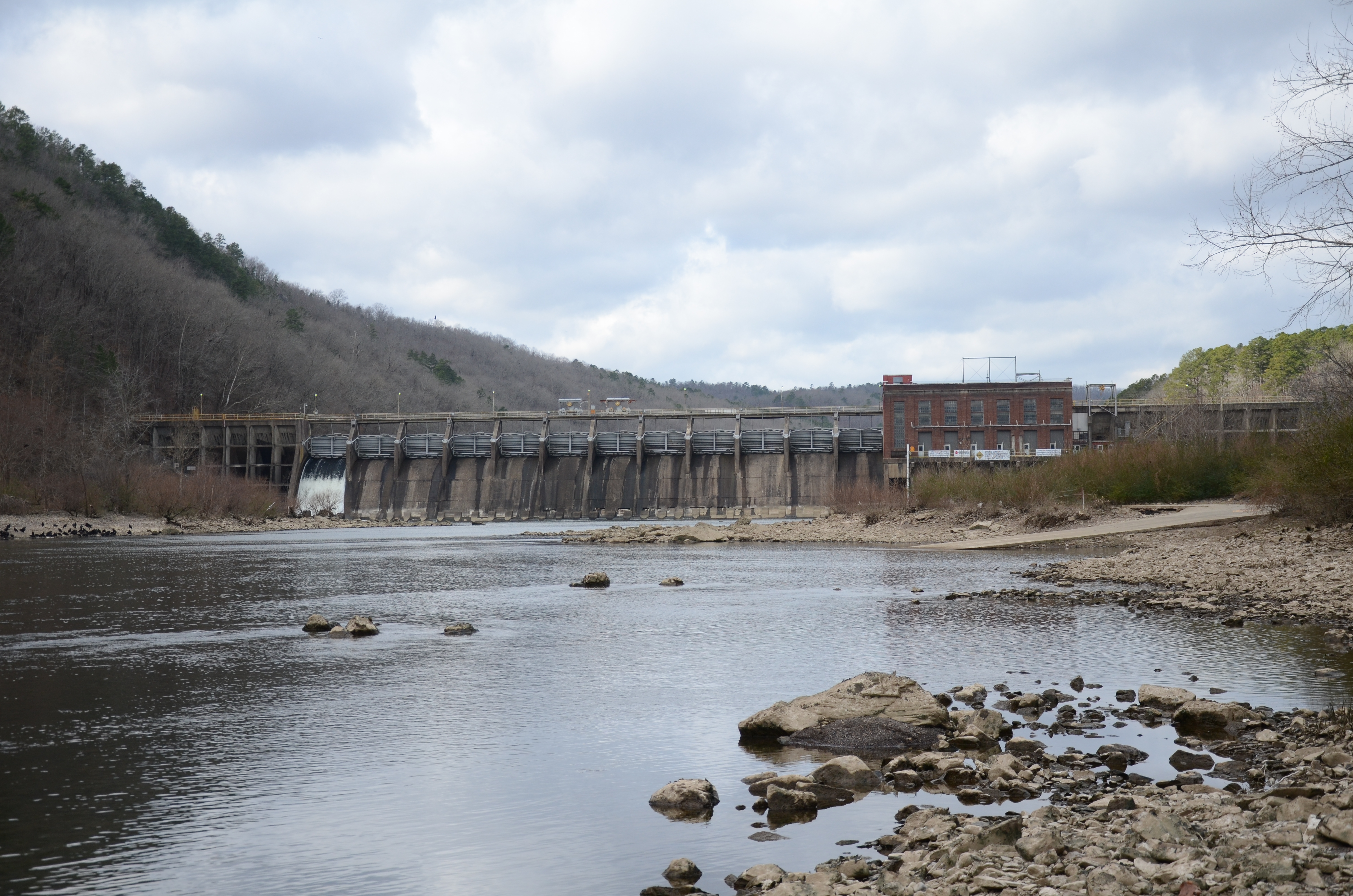
Launch below Remmel Dam and take out at Ouachita River Whitewater Park for the standard Rockport / Malvern float. Use the Remmel Dam USGS gauge, Entergy release guidance, and same-day weather before launching, and make an active left-bank take-out plan before Rockport Ledge and the I-30 bridge.
Put-in
Remmel Dam tailrace / below-dam river access Open mapThe put-in coordinate is a practical Remmel Dam gauge/access-area anchor, not a survey-grade boat-ramp point. Use Entergy signs and the posted gate/parking layout to find the active launch.
Take-out
Ouachita River Whitewater Park / Rockport Open mapThe Remmel Dam gate closes nightly at 10 p.m.; retrieve vehicles before the gate closes and do not depend on overnight access.
Pulling access map tiles. Usually under 5 seconds.
Access caveats
- The put-in coordinate is a practical Remmel Dam gauge/access-area anchor, not a survey-grade boat-ramp point. Use Entergy signs and the posted gate/parking layout to find the active launch.
- The Remmel Dam gate closes nightly at 10 p.m.; retrieve vehicles before the gate closes and do not depend on overnight access.
- Entergy says some navigation apps may misroute users near Remmel Dam. From I-30, use Exit 98B / Highway 270 toward Hot Springs and confirm the signed dam access in daylight.
- At the take-out, Entergy says to move to the left bank when the I-30 bridge comes into view. The boat ramp is on the left after the rapid but before the bridge; missing it can leave paddlers fighting current back upstream.
Watch for
- Rockport Ledge at the take-out, including chutes that can flip, pin, or swamp canoes and the far-right Lion's Den / Tiger hazard.
- Dam-release changes, strong current, undertows, cold tailwater, sirens or warning signs, and fast water-level changes from weather or power operations.
- Flows near 200-500 cfs may be kayakable but scrape-through and slow. Entergy says lower than about 3,200 cfs can be too low for an enjoyable tube float.
- Flows above 4,000 cfs are outside Entergy's floating recommendation; skip the route if water is above the group skill set, rising quickly, or affected by storm runoff.
- Crowded summer release windows, tubers tied together, swimmers at the Whitewater Park, rocks, slippery exits, limited rescue margin at the ledge, and late-day darkness.
Route gallery
See this route on the water
Photos help show what the access looks like and what the route actually feels like on the water.
Sources
Check the data behind today's call.
Use this section when the page shows stale data, limited confidence, or a call you want to verify before driving.
Why this score Today's data confidence is checking
Data confidence mostly comes down to three things: how direct the gauge is, how clear the range is, and how fresh the data is.
- Checking data confidence notes.
- Checking data confidence cautions.
Outlook Tomorrow and weekend
This is a cautious early look. If the data is too thin, we leave it out.
Waiting on forecast.
Waiting on forecast.
Data behind the score Gauge, thresholds, and timing
These are the live readings and threshold notes behind today's score.
| Gauge site | Ouachita River at Remmel Dam above Jones Mill, AR |
| Discharge | Checking |
| Gauge height | Checking |
| 24h trend | Checking |
| 24h change | Checking |
| Current band | Checking |
| Rain last 24h | Checking |
| Rain last 72h | Checking |
| Air temp | Checking |
| Water temp | Checking |
| Wind | Checking |
| Gusts | Checking |
| Rain timing | Checking |
| Target band | 3,500 cfs to 4,000 cfs |
| Low threshold | 200 cfs |
| High threshold | 4,000 cfs |
| Data confidence behind the range | Official and local sources |
| Gauge observed | Checking |
| Paddle Today updated | Checking |
| Main source behind this score | Entergy recreational-flow guidance and American Whitewater Remmel-to-I-30 gauge notes |
| Gauge source | Checking |
| Weather source | Checking |
| Rainfall source | Checking |
Notes What to know before you go
These notes cover the access details, route quirks, and source caveats most likely to matter once you get there.
- Official float logistics Remmel Dam to Whitewater Park
Entergy says weekend summer floaters bring tubes, kayaks, and canoes to Remmel Dam and exit at Ouachita River Whitewater Park in Malvern, with the access gate just past the Remmel Dam operations entrance and the exit at 904 Riverview Drive.
- Direct live gauge USGS 07359002
USGS Ouachita River at Remmel Dam above Jones Mill showed same-day June 1, 2026 values during review, including 363 cfs and 2.88 ft at 00:15 CDT.
- Threshold model 200 / 3,500-4,000 / 4,000 cfs
American Whitewater says 200-500 cfs is enough to make it downriver with scraping and that normal generation is 3,500-4,000 cfs. Entergy says flows lower than 3,200 cfs may be too low for an enjoyable tube float, 3,500-4,000 cfs is good for recreation, and flows above 4,000 cfs are not recommended for floating.
- Whitewater reach match 5.9 mi Class I-II
American Whitewater identifies Remmel Dam to I-30 at Malvern as a 5.9-mile I-II reach on the Ouachita River, with Rockport Ledge near the take-out and a warning that some chutes can flip, pin, or swamp canoes.
- Access coordinates Remmel gauge/access area 34.426111, -92.890833; Whitewater Park 34.39427, -92.84158
The put-in coordinate is the USGS/AW Remmel Dam gauge/access-area anchor adjacent to Entergy's below-dam access instructions. Mapcarta/OpenStreetMap places Ouachita River Whitewater Park at 904 Riverview Drive with coordinates 34.39427, -92.84158.
- Dam-release safety Gate hours, release changes, and cold tailwater
Entergy warns release plans can change without notice, the Remmel Dam gate closes nightly at 10 p.m., no-parking zones are marked at the dam, and the take-out current can push paddlers past the Whitewater Park ramp if they miss the left-bank exit.
Verify it yourself Check the source links
Use these links to double-check the gauge, route details, and access notes before you head out.
Paddler reports
Recent notes from paddlers
A few quick notes from people who were on this route recently.
Reports
Photos, paddler notes, and updates.
See what others have shared, then add a condition report, upload photos, or flag anything that needs fixing.
Share your trip
Keep exploring
More routes to check next
Compare another stretch on this river, or jump to nearby options before you pick a plan.
Quick answers
Ouachita River paddling FAQ
What water level is good for paddling Ouachita River?
Paddle Today watches Ouachita River at Remmel Dam above Jones Mill, AR and treats 3,500 cfs to 4,000 cfs as the target band for this route, with weather and recent trend included in the final score.
Where does this Ouachita River route start and end?
This route starts at Remmel Dam tailrace / below-dam river access and ends at Ouachita River Whitewater Park / Rockport, about About 5.9 to 6 mi on the water.
Is this Ouachita River route good for beginners?
This is listed as a moderate route. Expect more planning than an easy float, and use the live score, route notes, and source links before committing.
Flag a change
See something outdated?
Access, hazards, wood, and shuttle details change. Send a quick correction if something looks off.