Ohio | Northeast Ohio
Grand River
Harpersfield Covered Bridge to Hidden Valley Park
Check current paddling conditions for this Grand River route, including water level, recent gauge trend, weather, and route details.
Route snapshot
Loading the route snapshot. This usually takes a few seconds.
Today
Get the answer fast, then scan the route.
Start with the verdict, current conditions, route plan, and quick facts before you commit to the drive.
Today's conditions
Gauge
Recent trend
Checking preferred range.
Checking trend.
Gauge source
-- Checking timestampMN DNR provides the current paddling level here, but not chart-ready recent samples.
Weather
Best window today
Checking weather.
Today by hour
Short-route forecast
Checking the next several hours.
Quick facts
Plan
Dial in the shuttle, distance, and access.
Use this section once the route looks viable and you need to turn it into an actual trip plan.
Access plan
Access, shuttle, and map
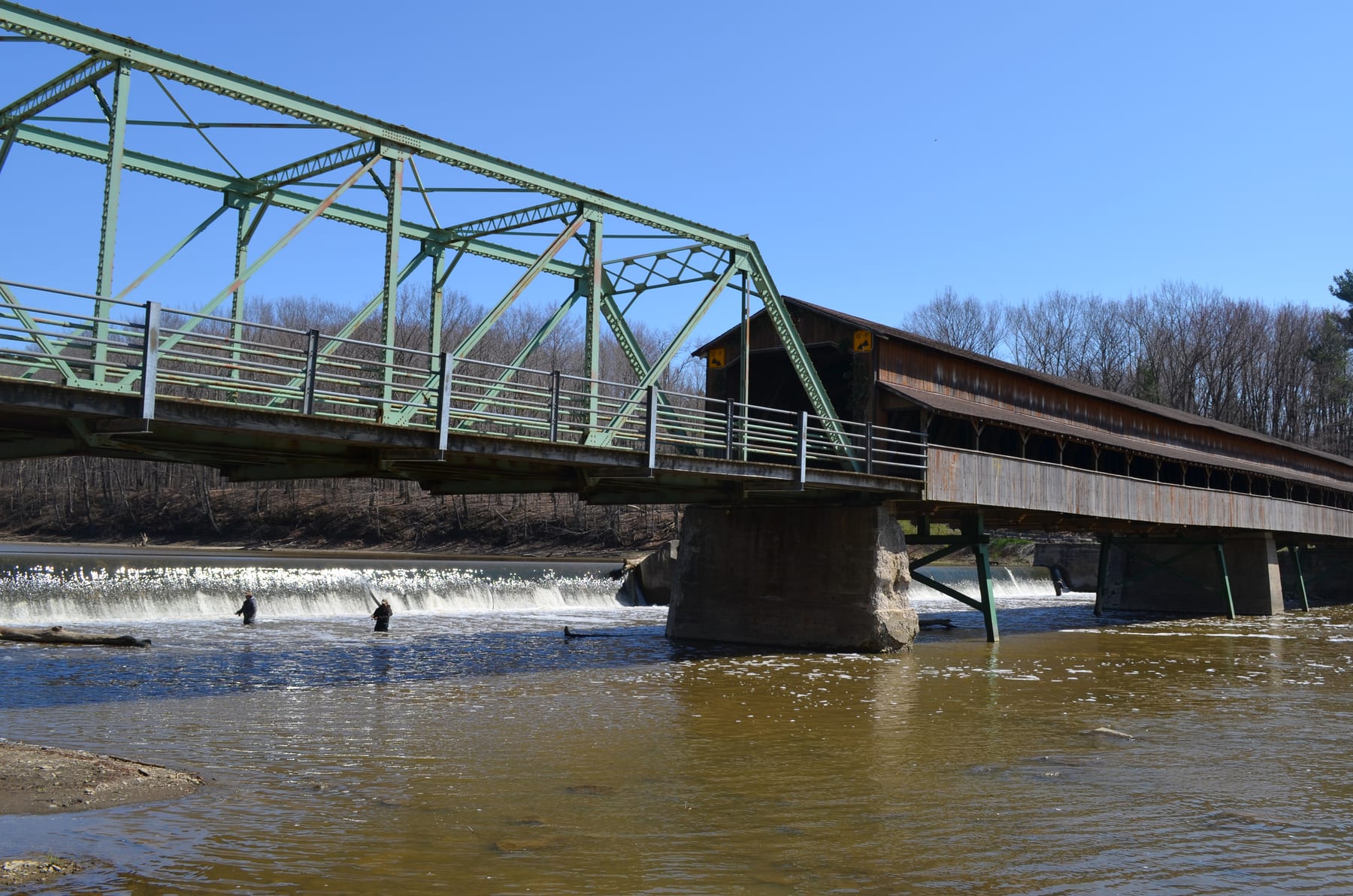
Put in below Harpersfield Covered Bridge and take out at Hidden Valley Park. This keeps the route to the AW-documented 8.4-mile Class I-II reach and the Lake Metroparks water-trail access pair.
Put-in
Harpersfield Covered Bridge access Open mapThe Harpersfield put-in is just below the covered bridge and ledge/play-spot area; scout the launch and current before committing.
Take-out
Hidden Valley Park paddle access Open mapHidden Valley Park is a public paddle access, but use the signed access and current park parking rules rather than informal banks.
Pulling access map tiles. Usually under 5 seconds.
Access caveats
- The Harpersfield put-in is just below the covered bridge and ledge/play-spot area; scout the launch and current before committing.
- Hidden Valley Park is a public paddle access, but use the signed access and current park parking rules rather than informal banks.
- The downstream Grand River corridor has additional accesses, but continuing past Hidden Valley changes the mileage, hazards, and shuttle plan.
Watch for
- Harpersfield ledge/drop features and standing waves, especially once levels rise above the easy end of the gauge band.
- Large wave trains and stronger eddy lines above the AW 1500 cfs intermediate-skills threshold.
- Wood, fast current, cold water in shoulder seasons, and floodplain closure risk during high or rising water.
Route gallery
See this route on the water
Photos help show what the access looks like and what the route actually feels like on the water.
Sources
Check the data behind today's call.
Use this section when the page shows stale data, limited confidence, or a call you want to verify before driving.
Why this score Today's data confidence is checking
Data confidence mostly comes down to three things: how direct the gauge is, how clear the range is, and how fresh the data is.
- Checking data confidence notes.
- Checking data confidence cautions.
Outlook Tomorrow and weekend
This is a cautious early look. If the data is too thin, we leave it out.
Waiting on forecast.
Waiting on forecast.
Data behind the score Gauge, thresholds, and timing
These are the live readings and threshold notes behind today's score.
| Gauge site | Grand River near Painesville, OH |
| Gauge height | Checking |
| Discharge | Checking |
| 24h trend | Checking |
| 24h change | Checking |
| Current band | Checking |
| Rain last 24h | Checking |
| Rain last 72h | Checking |
| Air temp | Checking |
| Water temp | Checking |
| Wind | Checking |
| Gusts | Checking |
| Rain timing | Checking |
| Target band | 2.00 ft to 5.00 ft |
| Low threshold | 2.00 ft |
| High threshold | 8.00 ft |
| Data confidence behind the range | Official and local sources |
| Gauge observed | Checking |
| Paddle Today updated | Checking |
| Main source behind this score | Lake Metroparks Grand River Water Trail gauge bands |
| Gauge source | Checking |
| Weather source | Checking |
| Rainfall source | Checking |
Notes What to know before you go
These notes cover the access details, route quirks, and source caveats most likely to matter once you get there.
- Official gauge bands 2 to 5 ft optimal; >8 ft dangerous
Lake Metroparks tells paddlers to check USGS 04212100 and labels under 2 ft low/slow drag, 2 to 5 ft optimal, 5 to 8 ft high/fast, and above 8 ft flood-level dangerous.
- AW route and distance 8.4 miles, Class I-II
American Whitewater lists Harpersfield Dam / Route 534 to Hidden Valley / Route 528 as an 8.4-mile Class I-II Grand River reach.
- AW flow floor About 100 cfs
AW trip-report guidance says boatable flows are about 100 cfs and that 90 cfs was too low in spots.
- AW beginner range 100 to 1500 cfs
AW reports 100 to 1500 cfs as a safe beginner/novice range and warns that above 1500 cfs a few spots need intermediate skills.
- Direct live gauge USGS 04212100
USGS identifies Grand River near Painesville, OH as station 04212100 and reports both gage height and discharge.
- Put-in coordinate support Harpersfield Covered Bridge: 41.75649, -80.946408
Lake Metroparks Grand River Water Trail map publishes the Harpersfield Covered Bridge access coordinate and address at 1122 Harpersfield Road.
- Take-out coordinate support Hidden Valley Park: 41.741864, -81.047837
Lake Metroparks Grand River Water Trail map publishes Hidden Valley Park as a paddle access with GIS coordinates and a short carry from drop-off to water.
Verify it yourself Check the source links
Use these links to double-check the gauge, route details, and access notes before you head out.
Paddler reports
Recent notes from paddlers
A few quick notes from people who were on this route recently.
Reports
Photos, paddler notes, and updates.
See what others have shared, then add a condition report, upload photos, or flag anything that needs fixing.
Share your trip
Keep exploring
More routes to check next
Compare another stretch on this river, or jump to nearby options before you pick a plan.
More in Ohio
All 5 routesNearby routes by distance
Quick answers
Grand River paddling FAQ
What water level is good for paddling Grand River?
Paddle Today watches Grand River near Painesville, OH and treats 2.00 ft to 5.00 ft as the target band for this route, with weather and recent trend included in the final score.
Where does this Grand River route start and end?
This route starts at Harpersfield Covered Bridge access and ends at Hidden Valley Park paddle access, about 8.4 mi on the water.
Is this Grand River route good for beginners?
This is listed as a moderate route. Expect more planning than an easy float, and use the live score, route notes, and source links before committing.
Flag a change
See something outdated?
Access, hazards, wood, and shuttle details change. Send a quick correction if something looks off.