Kentucky | Eastern Kentucky
Levisa Fork
Cedar Creek Ramp to Thompson Road Ramp
Check current paddling conditions for this Levisa Fork route, including water level, recent gauge trend, weather, and route details.
Route snapshot
Loading the route snapshot. This usually takes a few seconds.
Today
Get the answer fast, then scan the route.
Start with the verdict, current conditions, route plan, and quick facts before you commit to the drive.
Today's conditions
Gauge
Recent trend
Checking preferred range.
Checking trend.
Gauge source
-- Checking timestampMN DNR provides the current paddling level here, but not chart-ready recent samples.
Weather
Best window today
Checking weather.
Today by hour
Short-route forecast
Checking the next several hours.
Quick facts
Plan
Dial in the shuttle, distance, and access.
Use this section once the route looks viable and you need to turn it into an actual trip plan.
Access plan
Access, shuttle, and map
Launch at Cedar Creek Canoe Access and take out three miles downstream at Thompson Road Canoe Access for the short Pikeville / Hatfield-McCoy River Trail segment through the Cut-Through corridor. KDFWR gives a good Pikeville gauge band of 800 to 1,400 cfs.
Put-in
Cedar Creek Canoe Access Open mapCedar Creek is a KDFWR carry-down access under the KY 1384 bridge with unpaved parking and no amenities.
Take-out
Thompson Road Canoe Access Open mapThompson Road is a KDFWR single-lane ramp with year-round availability, but land around the ramp is private or thickly vegetated; land at the signed access rather than spreading onto nearby banks.
Pulling access map tiles. Usually under 5 seconds.
Access caveats
- Cedar Creek is a KDFWR carry-down access under the KY 1384 bridge with unpaved parking and no amenities.
- Thompson Road is a KDFWR single-lane ramp with year-round availability, but land around the ramp is private or thickly vegetated; land at the signed access rather than spreading onto nearby banks.
- KDFWR notes bank and wade fishing are limited at these sites because surrounding land is private, steep, rocky, or heavily vegetated. Stay with the documented public ramps and do not assume private-bank stops are allowed.
- The app uses USGS 03209500 as the direct gauge. The official USGS inventory page was stale during review, so same-day live confirmation came from RiverApp text that says it imports this station from USGS Water Services.
Watch for
- Woody debris, root wads, strainers, and bridge approaches, especially after storms or release changes.
- Low water below 800 cfs or 7.4 ft, when shallow shoals and dragging become more likely.
- High water above 1,400 cfs or 8.5 ft, when KDFWR moves the Pikeville reach out of the good band and swift current can make wood and landings dangerous.
- Fishtrap Lake release changes and Russell Fork inflow upstream; do not treat a stable-looking ramp as a substitute for checking the gauge trend.
- Private banks and urban corridor hazards; keep the trip to the named access points unless there is an emergency.
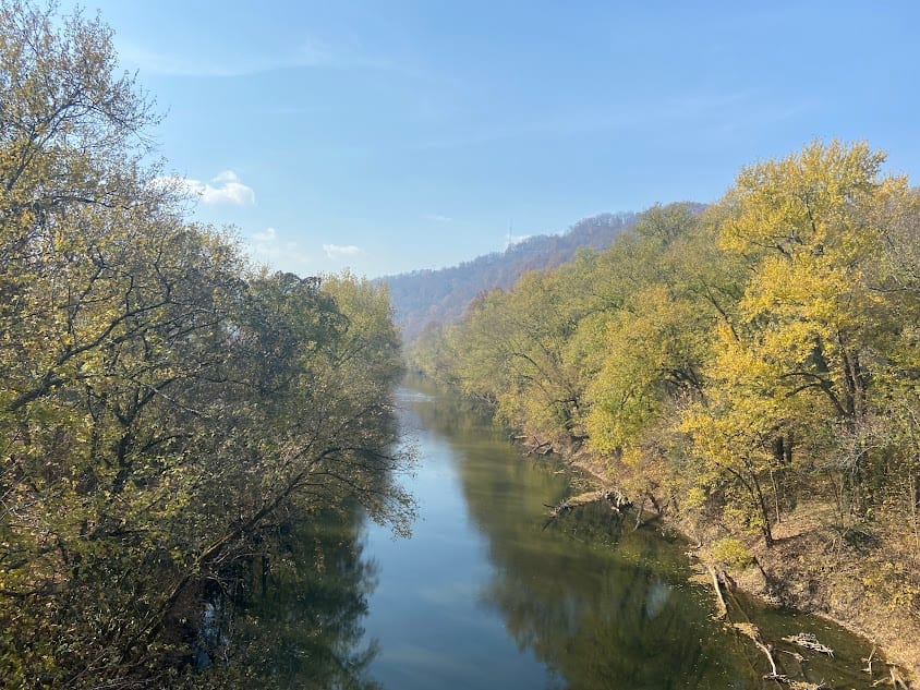
Route gallery
See this route on the water
Photos help show what the access looks like and what the route actually feels like on the water.
Sources
Check the data behind today's call.
Use this section when the page shows stale data, limited confidence, or a call you want to verify before driving.
Why this score Today's data confidence is checking
Data confidence mostly comes down to three things: how direct the gauge is, how clear the range is, and how fresh the data is.
- Checking data confidence notes.
- Checking data confidence cautions.
Outlook Tomorrow and weekend
This is a cautious early look. If the data is too thin, we leave it out.
Waiting on forecast.
Waiting on forecast.
Data behind the score Gauge, thresholds, and timing
These are the live readings and threshold notes behind today's score.
| Gauge site | Levisa Fork at Pikeville, KY |
| Discharge | Checking |
| Gauge height | Checking |
| 24h trend | Checking |
| 24h change | Checking |
| Current band | Checking |
| Rain last 24h | Checking |
| Rain last 72h | Checking |
| Air temp | Checking |
| Water temp | Checking |
| Wind | Checking |
| Gusts | Checking |
| Rain timing | Checking |
| Target band | 800 cfs to 1,400 cfs |
| Low threshold | 800 cfs |
| High threshold | 1,400 cfs |
| Data confidence behind the range | Official data source |
| Gauge observed | Checking |
| Paddle Today updated | Checking |
| Main source behind this score | KDFWR recommended river levels for Levisa Fork at Pikeville |
| Gauge source | Checking |
| Weather source | Checking |
| Rainfall source | Checking |
Notes What to know before you go
These notes cover the access details, route quirks, and source caveats most likely to matter once you get there.
- Official level band 800-1,400 cfs / 7.4-8.5 ft
KDFWR rates Levisa Fork at Pikeville as Low below 800 cfs or 7.4 ft, Good from 800 to 1,400 cfs or 7.4 to 8.5 ft, and High above 1,400 cfs or 8.5 ft.
- Official route segment Cedar Creek Ramp to Thompson Road Ramp, 3.0 miles
KDFWR lists Cedar Creek Ramp to Thompson Road Ramp as a 3.0-mile public-access segment on the Levisa Fork access mileage table.
- Put-in access Cedar Creek Canoe Access, 37.4802, -82.5446
KDFWR identifies Cedar Creek Canoe Access under the KY-1384 bridge in Pikeville as a free carry-down site with unpaved parking.
- Take-out access Thompson Road Canoe Access, 37.5096, -82.5435
KDFWR identifies Thompson Road Canoe Access as a free single-lane ramp with year-round 24-hour boat-ramp availability and published coordinates.
- Route character Class I beginner-friendly at normal levels
Visit Pikeville describes the Hatfield-McCoy River Trail trip through the Pikeville Cut-Through as Class I water suitable for beginners and families.
- Live-gauge support USGS 03209500
RiverApp showed same-day May 31, 2026 Pikeville readings and says values for this station are imported from USGS Water Services. The official USGS inventory page remains stale, so this route keeps that caveat visible.
Verify it yourself Check the source links
Use these links to double-check the gauge, route details, and access notes before you head out.
Paddler reports
Recent notes from paddlers
A few quick notes from people who were on this route recently.
Reports
Photos, paddler notes, and updates.
See what others have shared, then add a condition report, upload photos, or flag anything that needs fixing.
Share your trip
Keep exploring
More routes to check next
Compare another stretch on this river, or jump to nearby options before you pick a plan.
More in Kentucky
All 8 routesNearby routes by distance
Quick answers
Levisa Fork paddling FAQ
What water level is good for paddling Levisa Fork?
Paddle Today watches Levisa Fork at Pikeville, KY and treats 800 cfs to 1,400 cfs as the target band for this route, with weather and recent trend included in the final score.
Where does this Levisa Fork route start and end?
This route starts at Cedar Creek Canoe Access and ends at Thompson Road Canoe Access, about 3.0 mi on the water.
Is this Levisa Fork route good for beginners?
This is listed as an easy route, but conditions still matter. Check today's score, water level, weather, and access notes before you go.
Flag a change
See something outdated?
Access, hazards, wood, and shuttle details change. Send a quick correction if something looks off.