See all 4 routes on Maquoketa River
Iowa | Northeast Iowa
Maquoketa River
Mon-Maq Dam Access to Pictured Rocks Park
Check current paddling conditions for this Maquoketa River route, including water level, recent gauge trend, weather, and route details.
Route snapshot
Loading the route snapshot. This usually takes a few seconds.
Today
Get the answer fast, then scan the route.
Start with the verdict, current conditions, route plan, and quick facts before you commit to the drive.
Today's conditions
Gauge
Recent trend
Checking preferred range.
Checking trend.
Gauge source
-- Checking timestampMN DNR provides the current paddling level here, but not chart-ready recent samples.
Weather
Best window today
Checking weather.
Today by hour
Short-route forecast
Checking the next several hours.
Quick facts
Plan
Dial in the shuttle, distance, and access.
Use this section once the route looks viable and you need to turn it into an actual trip plan.
Access plan
Access, shuttle, and map
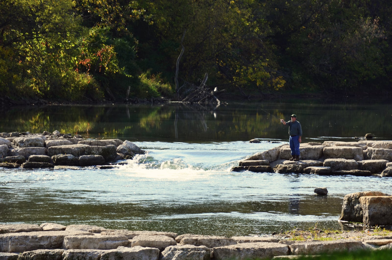
Launch from the sandbar access below Mon-Maq Dam and paddle the classic lower-Maquoketa bluff section to the hard-surface Pictured Rocks Park access. Expect steady current, wooded banks, limestone outcrops, public wildlife-area scenery, and a popular take-out with parking and restrooms.
Put-in
Mon-Maq Dam Access / Lower Mon-Maq sandbar launch Open mapThe practical put-in is below the Mon-Maq Dam, not above it. Use the lower sandbar/access area and stay clear of dam hydraulics.
Take-out
Pictured Rocks Park Access Open mapPictured Rocks has hard-surface river access, parking, restrooms, and water in the water-trail guide, but Jones County notes the steep access road is typically closed after the first snowfall.
Pulling access map tiles. Usually under 5 seconds.
Access caveats
- The practical put-in is below the Mon-Maq Dam, not above it. Use the lower sandbar/access area and stay clear of dam hydraulics.
- Pictured Rocks has hard-surface river access, parking, restrooms, and water in the water-trail guide, but Jones County notes the steep access road is typically closed after the first snowfall.
- Summer weekends can be busy because this is one of the better-known lower-Maquoketa bluff runs and Pictured Rocks also draws hikers and climbers.
Watch for
- Shallow gravel bars and grounding risk below about 500 cfs on the Maquoketa near Maquoketa gauge.
- Eight miles of moving water, which the official guide says can be long for beginners even though the section is not technical.
- Pushier, dirtier current above about 2,000 cfs, especially around outside bends, wood, bridge areas, and the Pictured Rocks landing.
- Private-property boundaries between public access areas and wildlife-area frontage.
Route gallery
See this route on the water
Photos help show what the access looks like and what the route actually feels like on the water.
Sources
Check the data behind today's call.
Use this section when the page shows stale data, limited confidence, or a call you want to verify before driving.
Why this score Today's data confidence is checking
Data confidence mostly comes down to three things: how direct the gauge is, how clear the range is, and how fresh the data is.
- Checking data confidence notes.
- Checking data confidence cautions.
Outlook Tomorrow and weekend
This is a cautious early look. If the data is too thin, we leave it out.
Waiting on forecast.
Waiting on forecast.
Data behind the score Gauge, thresholds, and timing
These are the live readings and threshold notes behind today's score.
| Gauge site | Maquoketa River near Maquoketa, IA |
| Discharge | Checking |
| Gauge height | Checking |
| 24h trend | Checking |
| 24h change | Checking |
| Current band | Checking |
| Rain last 24h | Checking |
| Rain last 72h | Checking |
| Air temp | Checking |
| Water temp | Checking |
| Wind | Checking |
| Gusts | Checking |
| Rain timing | Checking |
| Target band | 701 cfs to 1,000 cfs |
| Low threshold | 500 cfs |
| High threshold | 2,001 cfs |
| Data confidence behind the range | Local route guidance |
| Gauge observed | Checking |
| Paddle Today updated | Checking |
| Main source behind this score | Wisconsin River Trips lower Maquoketa gauge ladder |
| Gauge source | Checking |
| Weather source | Checking |
| Rainfall source | Checking |
Notes What to know before you go
These notes cover the access details, route quirks, and source caveats most likely to matter once you get there.
- Official water-trail route Mon-Maq Dam to Pictured Rocks Park
The Iowa DNR/Jones County water-trail guide describes the sandbar access below Mon-Maq Dam, the Pictured Rocks stone boat ramp, amenities at both accesses, and the eight-mile route as suitable for all skill levels though long for beginners.
- County paddling access Pictured Rocks Park
Jones County describes Pictured Rocks along the Maquoketa River, notes paddling among steep limestone bluffs, and confirms hard-surface river access.
- DNR lower-river access context Pictured Rocks hard-surface boat ramp
Iowa DNR Fish Iowa lists Pictured Rocks Park among the hard surface boat ramps on the lower Maquoketa and describes the upper part of the below-Monticello segment as more accessible by canoe or small jon boat.
- Published route context Monticello Dam Lower Access to Pictured Rocks Boat Ramp
Wisconsin River Trips identifies this 8.1-mile leg as the start of one of the more popular and scenic lower-Maquoketa stretches with elevated limestone outcrops and possible summer-weekend crowds.
- Target range 701 to 1,000 cfs
WRT describes 701 to 1,000 cfs on the Maquoketa near Maquoketa gauge as an average fall depth and good target range for the lower river.
- Low-water floor 500 cfs
The same WRT ladder treats less than 500 cfs as likely too low for enjoyable paddling and 501 to 700 cfs as mostly okay but with grounding risk.
- High-water ceiling 2,001+ cfs
WRT treats 2,001+ cfs as very high, pushy, dirty water that may be beyond enjoyable paddling on the lower Maquoketa.
- Direct gauge USGS 05418500
USGS operates Maquoketa River near Maquoketa, IA downstream on the same river, and WRT uses this gauge for its lower-Maquoketa ladder.
- Endpoint coordinates Mon-Maq 42.24511929, -91.17077245; Pictured Rocks 42.20569962, -91.10253825
Water Quality Portal sites named AWARE 9 Mon-Maq Dam Maquoketa River and AWARE 10 Pictured Rocks Park Maquoketa River provide NAD83 coordinates for the named endpoint corridors.
- Hazards Length, crowds, access road, high water
The route is not technical, but eight miles can be long for beginners, Pictured Rocks has a steep seasonal access road, summer weekends can be busy, and very high water makes the lower river pushier and dirtier.
Verify it yourself Check the source links
Use these links to double-check the gauge, route details, and access notes before you head out.
- Iowa DNR Maquoketa River Water Trail
- Jones County Pictured Rocks
- Iowa DNR Fish Iowa Maquoketa below Monticello
- Wisconsin River Trips Maquoketa River - Buzzard Ridge
- USGS 05418500 monitoring location
- Water Quality Portal Mon-Maq Dam
- Water Quality Portal Pictured Rocks Park
- USGS public-domain Maquoketa River image
Paddler reports
Recent notes from paddlers
A few quick notes from people who were on this route recently.
Reports
Photos, paddler notes, and updates.
See what others have shared, then add a condition report, upload photos, or flag anything that needs fixing.
Share your trip
Keep exploring
More routes to check next
Compare another stretch on this river, or jump to nearby options before you pick a plan.
Quick answers
Maquoketa River paddling FAQ
What water level is good for paddling Maquoketa River?
Paddle Today watches Maquoketa River near Maquoketa, IA and treats 701 cfs to 1,000 cfs as the target band for this route, with weather and recent trend included in the final score.
Where does this Maquoketa River route start and end?
This route starts at Mon-Maq Dam Access / Lower Mon-Maq sandbar launch and ends at Pictured Rocks Park Access, about 8 to 8.1 mi on the water.
Is this Maquoketa River route good for beginners?
This is listed as an easy route, but conditions still matter. Check today's score, water level, weather, and access notes before you go.
Flag a change
See something outdated?
Access, hazards, wood, and shuttle details change. Send a quick correction if something looks off.