South Dakota | Sioux Falls
Skunk Creek
Legacy Park to Farm Field Park
Check current paddling conditions for this Skunk Creek route, including water level, recent gauge trend, weather, and route details.
Route snapshot
Loading the route snapshot. This usually takes a few seconds.
Today
Get the answer fast, then scan the route.
Start with the verdict, current conditions, route plan, and quick facts before you commit to the drive.
Today's conditions
Gauge
Recent trend
Checking preferred range.
Checking trend.
Gauge source
-- Checking timestampMN DNR provides the current paddling level here, but not chart-ready recent samples.
Weather
Best window today
Checking weather.
Today by hour
Short-route forecast
Checking the next several hours.
Quick facts
Plan
Dial in the shuttle, distance, and access.
Use this section once the route looks viable and you need to turn it into an actual trip plan.
Access plan
Access, shuttle, and map
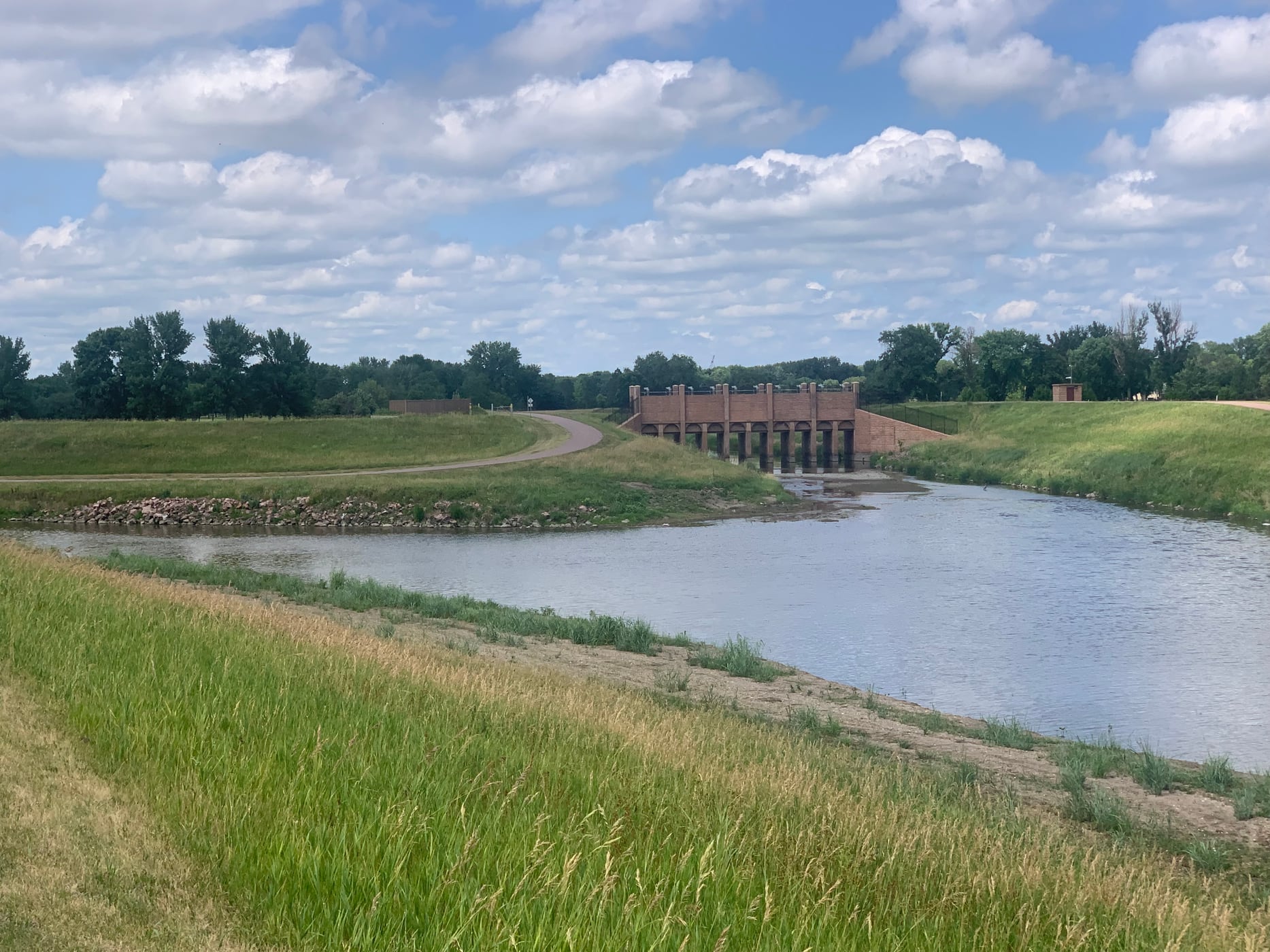
Launch at Legacy Park and take out at Farm Field Park for the short Sioux Falls Skunk Creek segment named by Sioux Empire Paddlers. The USGS Skunk Creek gauge is the direct same-creek low-water check.
Put-in
Legacy Park boat/canoe/kayak access Open mapLegacy Park and Farm Field Park are city-managed public parks with boat/canoe/kayak access, but park hours, events, construction, or temporary creek-bank conditions can affect parking and landing space.
Take-out
Farm Field Park kayak and canoe access Open mapThis route ends at Farm Field Park near the Big Sioux River corridor. Do not continue onto the Big Sioux, downtown channels, Falls Park, or any low-head-dam area without separate route planning and current local hazard information.
Pulling access map tiles. Usually under 5 seconds.
Access caveats
- Legacy Park and Farm Field Park are city-managed public parks with boat/canoe/kayak access, but park hours, events, construction, or temporary creek-bank conditions can affect parking and landing space.
- This route ends at Farm Field Park near the Big Sioux River corridor. Do not continue onto the Big Sioux, downtown channels, Falls Park, or any low-head-dam area without separate route planning and current local hazard information.
- Urban water quality is part of the go/no-go decision. Check the City of Sioux Falls water-quality dashboard when available, avoid immersion, and be especially cautious after heavy rain or visible pollution.
Watch for
- Dragging, walking, and shallow riffles when the Skunk Creek gauge is below the 4.5 ft floor.
- Storm debris, strainers, bridge approaches, exposed rocks, trash, and tight bends after rain or high water.
- Limited-contact urban water, including E. coli risk during the May-to-September monitoring season.
- Fences or other obstructions can occur on South Dakota navigable streams; scout any unexpected obstruction rather than forcing it.
Route gallery
See this route on the water
Photos help show what the access looks like and what the route actually feels like on the water.
Sources
Check the data behind today's call.
Use this section when the page shows stale data, limited confidence, or a call you want to verify before driving.
Why this score Today's data confidence is checking
Data confidence mostly comes down to three things: how direct the gauge is, how clear the range is, and how fresh the data is.
- Checking data confidence notes.
- Checking data confidence cautions.
Outlook Tomorrow and weekend
This is a cautious early look. If the data is too thin, we leave it out.
Waiting on forecast.
Waiting on forecast.
Data behind the score Gauge, thresholds, and timing
These are the live readings and threshold notes behind today's score.
| Gauge site | Skunk Creek at Sioux Falls, SD |
| Gauge height | Checking |
| Discharge | Checking |
| 24h trend | Checking |
| 24h change | Checking |
| Current band | Checking |
| Rain last 24h | Checking |
| Rain last 72h | Checking |
| Air temp | Checking |
| Water temp | Checking |
| Wind | Checking |
| Gusts | Checking |
| Rain timing | Checking |
| Ideal range | Needs paddler reports |
| Known low-water floor | 4.50 ft |
| High threshold | Not calibrated yet |
| Data confidence behind the range | Local route guidance |
| Gauge observed | Checking |
| Paddle Today updated | Checking |
| Main source behind this score | Sioux Empire Paddlers Skunk Creek Sioux Falls route guidance |
| Gauge source | Checking |
| Weather source | Checking |
| Rainfall source | Checking |
Notes What to know before you go
These notes cover the access details, route quirks, and source caveats most likely to matter once you get there.
- Route-specific guide Legacy Park to Farm Field Park, 5 mi
Sioux Empire Paddlers lists Skunk Creek at Legacy Park as point 1 on the Sioux Falls in-town map, says it flows into the Big Sioux River, and gives 5 miles to Farm Field Park.
- Low-water floor 4.5 ft minimum-only
Sioux Empire Paddlers says 4.5 ft and up is a good paddling level for the Skunk Creek Sioux Falls flow link. The app uses only that conservative floor and does not infer an ideal or high-water band.
- Direct gauge USGS 06481500
USGS operates Skunk Creek at Sioux Falls, SD. During the May 26, 2026 review, the legacy current-conditions page showed same-day discharge and gage-height observations.
- Public put-in Legacy Park boat/canoe/kayak access
City of Sioux Falls lists Legacy Park with boat/canoe/kayak access, restrooms, public park hours, and coordinates at 7001 W. 12th St.
- Public take-out Farm Field Park kayak and canoe access
City of Sioux Falls lists Farm Field Park with kayak and canoe access, a boat-launch photo, public park hours, and coordinates at 4401 S Western Ave.
- Water quality Weekly city monitoring May-Sep for E. coli
City of Sioux Falls monitors Big Sioux River and Skunk Creek water quality, including one Skunk Creek location and E. coli from May through September. Check the city dashboard and avoid contact after heavy rain or known poor results.
- South Dakota stream hazard Fence caution
South Dakota GFP warns that fences cross many navigable streams in the state. Scout any unexpected obstruction rather than forcing it.
Verify it yourself Check the source links
Use these links to double-check the gauge, route details, and access notes before you head out.
Paddler reports
Recent notes from paddlers
A few quick notes from people who were on this route recently.
Reports
Photos, paddler notes, and updates.
See what others have shared, then add a condition report, upload photos, or flag anything that needs fixing.
Share your trip
Keep exploring
More routes to check next
Compare another stretch on this river, or jump to nearby options before you pick a plan.
More in South Dakota
All 3 routesNearby routes by distance
Quick answers
Skunk Creek paddling FAQ
What water level is good for paddling Skunk Creek?
Paddle Today watches Skunk Creek at Sioux Falls, SD and uses 4.50 ft as the conservative low-water floor for this route. The ideal range still needs more paddler reports.
Where does this Skunk Creek route start and end?
This route starts at Legacy Park boat/canoe/kayak access and ends at Farm Field Park kayak and canoe access, about About 5 mi on the water.
Is this Skunk Creek route good for beginners?
This is listed as an easy route, but conditions still matter. Check today's score, water level, weather, and access notes before you go.
Flag a change
See something outdated?
Access, hazards, wood, and shuttle details change. Send a quick correction if something looks off.