South Dakota | Southeast South Dakota
Split Rock Creek
Split Rock Park to Palisades State Park
Check current paddling conditions for this Split Rock Creek route, including water level, recent gauge trend, weather, and route details.
Route snapshot
Loading the route snapshot. This usually takes a few seconds.
Today
Get the answer fast, then scan the route.
Start with the verdict, current conditions, route plan, and quick facts before you commit to the drive.
Today's conditions
Gauge
Recent trend
Checking preferred range.
Checking trend.
Gauge source
-- Checking timestampMN DNR provides the current paddling level here, but not chart-ready recent samples.
Weather
Best window today
Checking weather.
Today by hour
Short-route forecast
Checking the next several hours.
Quick facts
Plan
Dial in the shuttle, distance, and access.
Use this section once the route looks viable and you need to turn it into an actual trip plan.
Access plan
Access, shuttle, and map
Launch from the city park access below the Split Rock Park dam and paddle the short quartzite creek corridor to Palisades State Park. Use the USGS Corson gauge as a direct same-creek low-water check, but make the final call by scouting ledges, fences, and wood.
Put-in
Split Rock Park canoe/kayak launch Open mapSplit Rock Park is a city park with a canoe/kayak launch downstream from the dam; do not launch above or near dam hydraulics without separate local scouting.
Take-out
Palisades State Park / Split Rock Creek access Open mapPalisades State Park is a fee state park. Confirm the practical landing and parking location on arrival, especially during busy warm-weather weekends.
Pulling access map tiles. Usually under 5 seconds.
Access caveats
- Split Rock Park is a city park with a canoe/kayak launch downstream from the dam; do not launch above or near dam hydraulics without separate local scouting.
- Palisades State Park is a fee state park. Confirm the practical landing and parking location on arrival, especially during busy warm-weather weekends.
- Coordinates are practical access anchors derived from named park/access map context, not a substitute for on-site signs and current park rules.
Watch for
- Shallow scraping below the 4.5 ft Corson-gauge floor used by the app.
- Class I-II ledges and riffles, with Class III behavior possible near high flows around 1,000 cfs.
- Fences, strainers, downed trees, tight banks, and fast rain-driven rises on a small creek.
- Cold water in spring and shoulder seasons, plus busy state-park users near the take-out.
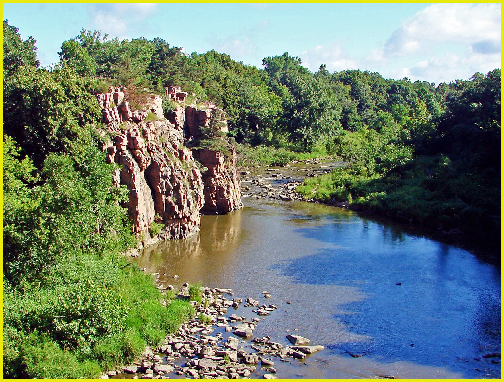
Route gallery
See this route on the water
Photos help show what the access looks like and what the route actually feels like on the water.
Sources
Check the data behind today's call.
Use this section when the page shows stale data, limited confidence, or a call you want to verify before driving.
Why this score Today's data confidence is checking
Data confidence mostly comes down to three things: how direct the gauge is, how clear the range is, and how fresh the data is.
- Checking data confidence notes.
- Checking data confidence cautions.
Outlook Tomorrow and weekend
This is a cautious early look. If the data is too thin, we leave it out.
Waiting on forecast.
Waiting on forecast.
Data behind the score Gauge, thresholds, and timing
These are the live readings and threshold notes behind today's score.
| Gauge site | Split Rock Creek at Corson, SD |
| Gauge height | Checking |
| Discharge | Checking |
| 24h trend | Checking |
| 24h change | Checking |
| Current band | Checking |
| Rain last 24h | Checking |
| Rain last 72h | Checking |
| Air temp | Checking |
| Water temp | Checking |
| Wind | Checking |
| Gusts | Checking |
| Rain timing | Checking |
| Ideal range | Needs paddler reports |
| Known low-water floor | 4.50 ft |
| High threshold | Not calibrated yet |
| Data confidence behind the range | Local route guidance |
| Gauge observed | Checking |
| Paddle Today updated | Checking |
| Main source behind this score | Sioux Empire Paddlers Split Rock Creek gauge and route guidance |
| Gauge source | Checking |
| Weather source | Checking |
| Rainfall source | Checking |
Notes What to know before you go
These notes cover the access details, route quirks, and source caveats most likely to matter once you get there.
- Route-specific guide 2.8 mi; Split Rock Park to Palisades State Park
Sioux Empire Paddlers describes the standard 2.8-mile route from the city park to Palisades State Park and ties it to the Split Rock Creek at Corson gauge.
- Low-water floor 4.5 ft minimum-only
Sioux Empire Paddlers says 4.5 ft or up on the USGS Corson gauge is best for this route. The app uses only that conservative floor and does not infer an ideal or high-water band.
- Direct gauge USGS 06482610
USGS operates Split Rock Creek at Corson, SD, the gauge named by the local route guide for the Split Rock Creek run.
- Public put-in Split Rock Park canoe/kayak launch
Visit Garretson describes Split Rock Park as a city park along Split Rock Creek and notes a canoe/kayak launch downstream from the dam.
- Public take-out Palisades State Park
South Dakota Game, Fish and Parks lists canoeing and kayaking on Split Rock Creek as an activity at Palisades State Park.
- Hazards Ledges, fences, wood, high-water wave
Local route guidance calls out ledges, possible fences across the creek, and stronger Class III behavior near 1,000 cfs; GFP also broadly warns that fences cross many navigable South Dakota streams.
Verify it yourself Check the source links
Use these links to double-check the gauge, route details, and access notes before you head out.
Paddler reports
Recent notes from paddlers
A few quick notes from people who were on this route recently.
Reports
Photos, paddler notes, and updates.
See what others have shared, then add a condition report, upload photos, or flag anything that needs fixing.
Share your trip
Keep exploring
More routes to check next
Compare another stretch on this river, or jump to nearby options before you pick a plan.
More in South Dakota
All 3 routesNearby routes by distance
Quick answers
Split Rock Creek paddling FAQ
What water level is good for paddling Split Rock Creek?
Paddle Today watches Split Rock Creek at Corson, SD and uses 4.50 ft as the conservative low-water floor for this route. The ideal range still needs more paddler reports.
Where does this Split Rock Creek route start and end?
This route starts at Split Rock Park canoe/kayak launch and ends at Palisades State Park / Split Rock Creek access, about About 2.8 mi on the water.
Is this Split Rock Creek route good for beginners?
This is listed as a moderate route. Expect more planning than an easy float, and use the live score, route notes, and source links before committing.
Flag a change
See something outdated?
Access, hazards, wood, and shuttle details change. Send a quick correction if something looks off.