See all 2 routes on North Fork of the White River
Missouri | Missouri Ozarks
North Fork of the White River
Blair Bridge Access to Dawt Mill
Check current paddling conditions for this North Fork of the White River route, including water level, recent gauge trend, weather, and route details.
Route snapshot
Loading the route snapshot. This usually takes a few seconds.
Today
Get the answer fast, then scan the route.
Start with the verdict, current conditions, route plan, and quick facts before you commit to the drive.
Today's conditions
Gauge
Recent trend
Checking preferred range.
Checking trend.
Gauge source
-- Checking timestampMN DNR provides the current paddling level here, but not chart-ready recent samples.
Weather
Best window today
Checking weather.
Today by hour
Short-route forecast
Checking the next several hours.
Quick facts
Plan
Dial in the shuttle, distance, and access.
Use this section once the route looks viable and you need to turn it into an actual trip plan.
Access plan
Access, shuttle, and map
Launch at MDC Blair Bridge Access and take out at private-fee Dawt Mill Resort for a 7.6-mile lower North Fork day. Use the downstream Tecumseh USGS gauge as a conservative low-water proxy, then make same-day calls around riffles, wood, Dawt Mill Dam, and the Dawt low-water bridge.
Put-in
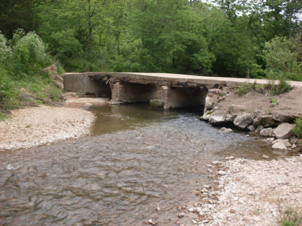
Blair Bridge Access Open mapBlair Bridge is public MDC floating access, but the route starts immediately around bridge current and old bridge-pier remnants. Inspect the launch and bridge approach before committing.
Take-out
Dawt Mill Resort private-fee river access Open mapDawt Mill is a private resort take-out. Current permission, reservation, shuttle, parking, and fee terms control; do not treat it as an unmanaged public access.
Pulling access map tiles. Usually under 5 seconds.
Access caveats
- Blair Bridge is public MDC floating access, but the route starts immediately around bridge current and old bridge-pier remnants. Inspect the launch and bridge approach before committing.
- Dawt Mill is a private resort take-out. Current permission, reservation, shuttle, parking, and fee terms control; do not treat it as an unmanaged public access.
- Dawt Mill Dam and the Dawt low-water bridge are near the finish. Low water can make the dam/bridge area awkward, while high water can make the bridge clearance and dam hydraulics dangerous.
- The Tecumseh gauge is downstream of this route and near additional inflow/backwater influence. Treat it as a supported proxy, not a perfect reading for every Blair-to-Dawt shoal.
Watch for
- Dragging and slow shoals when the Tecumseh gauge falls near the 300 cfs floor.
- Blair Bridge current, old bridge-pier remnants, swift riffles, root wads, fresh wood, and strainers on outside bends.
- Dawt Mill Dam, the low-water bridge at Dawt, and possible Norfork Lake backwater effects near the lower end of the reach.
- High or rising water after rain, when the dam, bridge, strainers, and resort landing become much less forgiving.
Route gallery
See this route on the water
Photos help show what the access looks like and what the route actually feels like on the water.
Sources
Check the data behind today's call.
Use this section when the page shows stale data, limited confidence, or a call you want to verify before driving.
Why this score Today's data confidence is checking
Data confidence mostly comes down to three things: how direct the gauge is, how clear the range is, and how fresh the data is.
- Checking data confidence notes.
- Checking data confidence cautions.
Outlook Tomorrow and weekend
This is a cautious early look. If the data is too thin, we leave it out.
Waiting on forecast.
Waiting on forecast.
Data behind the score Gauge, thresholds, and timing
These are the live readings and threshold notes behind today's score.
| Gauge site | North Fork River near Tecumseh, MO |
| Discharge | Checking |
| Gauge height | Checking |
| 24h trend | Checking |
| 24h change | Checking |
| Current band | Checking |
| Rain last 24h | Checking |
| Rain last 72h | Checking |
| Air temp | Checking |
| Water temp | Checking |
| Wind | Checking |
| Gusts | Checking |
| Rain timing | Checking |
| Ideal range | Needs paddler reports |
| Known low-water floor | 300 cfs |
| High threshold | Not calibrated yet |
| Data confidence behind the range | Local route guidance |
| Gauge observed | Checking |
| Paddle Today updated | Checking |
| Main source behind this score | Rivers.MOHERP Tecumseh gauge rating and Blair-to-Dawt trip logs |
| Gauge source | Checking |
| Weather source | Checking |
| Rainfall source | Checking |
Notes What to know before you go
These notes cover the access details, route quirks, and source caveats most likely to matter once you get there.
- Route shape Blair Bridge to Dawt, about 7.6 river miles
Float Missouri republishes MDC North Fork mile notes that place Blair Bridge Access at river mile 39.4 and Dawt Mill / Dawt Bridge at river mile 47.0-47.1; MoHERP exact Blair-to-Dawt trip rows list 7.6 miles.
- Public put-in MDC Blair Bridge Access
MDC says Blair Bridge Access offers fishing and floating access to the North Fork of the White River, with picnic tables, privy, campfire rings, and a concrete boat ramp.
- Private-fee take-out Dawt Mill Resort
Dawt Mill says it offers floating and lodging, direct river access, and transportation upstream so groups can float back to their vehicle or lodging at the resort. Use this route only with current permission, reservation, or fee terms.
- Proxy gauge USGS 07057500
USGS operates the North Fork River near Tecumseh gauge downstream of Dawt Mill. It showed same-day May 31, 2026 values of 1,220 cfs and 3.50 ft at 15:00 CDT during review.
- Low-water floor 300 cfs minimum-only
Rivers.MOHERP rates the Tecumseh gauge good beginning at 120 cfs and includes exact Blair-to-Dawt good rows at 428 and 811 cfs. The app keeps the same conservative 300 cfs floor used for adjacent North Fork coverage rather than claiming an ideal range.
- Hazards Blair Bridge, Dawt Mill Dam, low-water bridge
Float Missouri / MDC mile notes warn to approach Blair Bridge cautiously, describe Dawt Mill Dam as a canoe-buster unless handled correctly, and warn that going under Dawt Bridge in high water is dangerous.
Verify it yourself Check the source links
Use these links to double-check the gauge, route details, and access notes before you head out.
Paddler reports
Recent notes from paddlers
A few quick notes from people who were on this route recently.
Reports
Photos, paddler notes, and updates.
See what others have shared, then add a condition report, upload photos, or flag anything that needs fixing.
Share your trip
Keep exploring
More routes to check next
Compare another stretch on this river, or jump to nearby options before you pick a plan.
More in Missouri
All 34 routesMore on North Fork of the White River
All 2Nearby routes by distance
Quick answers
North Fork of the White River paddling FAQ
What water level is good for paddling North Fork of the White River?
Paddle Today watches North Fork River near Tecumseh, MO and uses 300 cfs as the conservative low-water floor for this route. The ideal range still needs more paddler reports.
Where does this North Fork of the White River route start and end?
This route starts at Blair Bridge Access and ends at Dawt Mill Resort private-fee river access, about About 7.6 mi on the water.
Is this North Fork of the White River route good for beginners?
This is listed as a moderate route. Expect more planning than an easy float, and use the live score, route notes, and source links before committing.
Flag a change
See something outdated?
Access, hazards, wood, and shuttle details change. Send a quick correction if something looks off.