See all 2 routes on North Fork of the White River
Missouri | Missouri Ozarks
North Fork of the White River
North Fork Recreation Area to Blair Bridge Access
Check current paddling conditions for this North Fork of the White River route, including water level, recent gauge trend, weather, and route details.
Route snapshot
Loading the route snapshot. This usually takes a few seconds.
Today
Get the answer fast, then scan the route.
Start with the verdict, current conditions, route plan, and quick facts before you commit to the drive.
Today's conditions
Gauge
Recent trend
Checking preferred range.
Checking trend.
Gauge source
-- Checking timestampMN DNR provides the current paddling level here, but not chart-ready recent samples.
Weather
Best window today
Checking weather.
Today by hour
Short-route forecast
Checking the next several hours.
Quick facts
Plan
Dial in the shuttle, distance, and access.
Use this section once the route looks viable and you need to turn it into an actual trip plan.
Access plan
Access, shuttle, and map
Launch at the Forest Service North Fork Recreation Area, locally known as Hammond Camp, and take out at MDC Blair Bridge Access for the official 10-mile North Fork day float. Expect cold spring-fed water, bluffs, shoals, Blue Spring access, The Falls, and a downstream Tecumseh gauge used as a conservative low-water proxy.
Put-in
North Fork Recreation Area / Hammond Camp Open mapNorth Fork Recreation Area is open and has a boat access, but the Forest Service notes a ramp-to-steps transition and a drop between the ramp end and riverbed, so expect a carry-down style launch rather than an easy trailer ramp.
Take-out
Blair Bridge Access Open mapBlair Bridge is public MDC floating access with a concrete boat ramp, but summer demand can be high and local signage should control parking and camping choices.
Pulling access map tiles. Usually under 5 seconds.
Access caveats
- North Fork Recreation Area is open and has a boat access, but the Forest Service notes a ramp-to-steps transition and a drop between the ramp end and riverbed, so expect a carry-down style launch rather than an easy trailer ramp.
- Blair Bridge is public MDC floating access with a concrete boat ramp, but summer demand can be high and local signage should control parking and camping choices.
- The Tecumseh gauge is downstream of the route and below additional inflow. Use it as a same-river proxy, not a perfect measure of every shoal between North Fork and Blair.
Watch for
- Dragging and slow shoals when the Tecumseh gauge falls near the 300 cfs floor.
- The Falls about 7 miles below North Fork Recreation Area; scout if the level, group skill, or boat load makes the two-foot drop feel questionable.
- Cold spring-fed water, swift riffles, fresh wood, strainers on bends, and faster current after rain.
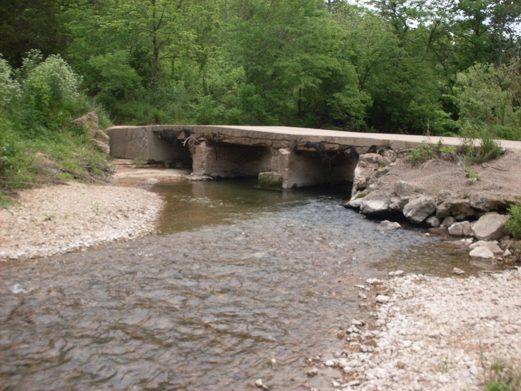
Route gallery
See this route on the water
Photos help show what the access looks like and what the route actually feels like on the water.
Sources
Check the data behind today's call.
Use this section when the page shows stale data, limited confidence, or a call you want to verify before driving.
Why this score Today's data confidence is checking
Data confidence mostly comes down to three things: how direct the gauge is, how clear the range is, and how fresh the data is.
- Checking data confidence notes.
- Checking data confidence cautions.
Outlook Tomorrow and weekend
This is a cautious early look. If the data is too thin, we leave it out.
Waiting on forecast.
Waiting on forecast.
Data behind the score Gauge, thresholds, and timing
These are the live readings and threshold notes behind today's score.
| Gauge site | North Fork River near Tecumseh, MO |
| Discharge | Checking |
| Gauge height | Checking |
| 24h trend | Checking |
| 24h change | Checking |
| Current band | Checking |
| Rain last 24h | Checking |
| Rain last 72h | Checking |
| Air temp | Checking |
| Water temp | Checking |
| Wind | Checking |
| Gusts | Checking |
| Rain timing | Checking |
| Ideal range | Needs paddler reports |
| Known low-water floor | 300 cfs |
| High threshold | Not calibrated yet |
| Data confidence behind the range | Local route guidance |
| Gauge observed | Checking |
| Paddle Today updated | Checking |
| Main source behind this score | Rivers.MOHERP Tecumseh gauge rating and Hammond-to-Blair trip logs |
| Gauge source | Checking |
| Weather source | Checking |
| Rainfall source | Checking |
Notes What to know before you go
These notes cover the access details, route quirks, and source caveats most likely to matter once you get there.
- Official route shape North Fork Recreation Area to Blair Bridge, about 10 river miles
The Forest Service says access south of North Fork is at Blair Bridge, operated by MDC, about 10 miles by river, and says this section can be floated all year.
- Public put-in North Fork Recreation Area / Hammond Camp
The Forest Service lists the site as open, with a boat access area, day-use parking, a concrete ramp to a stepped river entry, and coordinates 36.758606, -92.152801.
- Public take-out Blair Bridge Access
MDC says Blair Bridge Access offers fishing and floating access to the North Fork of the White River, with picnic tables, privy, campfire rings, and a concrete boat ramp.
- Proxy gauge USGS 07057500
USGS operates the North Fork River near Tecumseh gauge downstream of Blair Bridge. It is a same-river live gauge, but it is still a downstream proxy rather than a gauge inside the North Fork-to-Blair reach.
- Low-water floor 300 cfs minimum-only
Rivers.MOHERP rates the Tecumseh gauge good at 120 cfs and above, but the app uses a more conservative 300 cfs floor because the exact Hammond Camp-to-Blair Bridge trip was logged good at 368 cfs and the gauge is downstream.
- Route character Cold spring flow, Blue Spring, The Falls
The Forest Service notes multiple springs, Blue Spring near the route, and The Falls about 7 miles downriver, with an average two-foot drop on the way to Blair Bridge.
Verify it yourself Check the source links
Use these links to double-check the gauge, route details, and access notes before you head out.
Paddler reports
Recent notes from paddlers
A few quick notes from people who were on this route recently.
Reports
Photos, paddler notes, and updates.
See what others have shared, then add a condition report, upload photos, or flag anything that needs fixing.
Share your trip
Keep exploring
More routes to check next
Compare another stretch on this river, or jump to nearby options before you pick a plan.
More in Missouri
All 34 routesMore on North Fork of the White River
All 2Nearby routes by distance
Quick answers
North Fork of the White River paddling FAQ
What water level is good for paddling North Fork of the White River?
Paddle Today watches North Fork River near Tecumseh, MO and uses 300 cfs as the conservative low-water floor for this route. The ideal range still needs more paddler reports.
Where does this North Fork of the White River route start and end?
This route starts at North Fork Recreation Area / Hammond Camp and ends at Blair Bridge Access, about About 10 mi on the water.
Is this North Fork of the White River route good for beginners?
This is listed as a moderate route. Expect more planning than an easy float, and use the live score, route notes, and source links before committing.
Flag a change
See something outdated?
Access, hazards, wood, and shuttle details change. Send a quick correction if something looks off.