See all 4 routes on Root River
Minnesota | Southeast Minnesota
Root River
Rushford to Houston
Check current paddling conditions for this Root River route, including water level, recent gauge trend, weather, and route details.
Route snapshot
Loading the route snapshot. This usually takes a few seconds.
Today
Get the answer fast, then scan the route.
Start with the verdict, current conditions, route plan, and quick facts before you commit to the drive.
Today's conditions
Gauge
Recent trend
Checking preferred range.
Checking trend.
Gauge source
-- Checking timestampMN DNR provides the current paddling level here, but not chart-ready recent samples.
Weather
Best window today
Checking weather.
Today by hour
Short-route forecast
Checking the next several hours.
Quick facts
Plan
Dial in the shuttle, distance, and access.
Use this section once the route looks viable and you need to turn it into an actual trip plan.
Access plan
Access, shuttle, and map
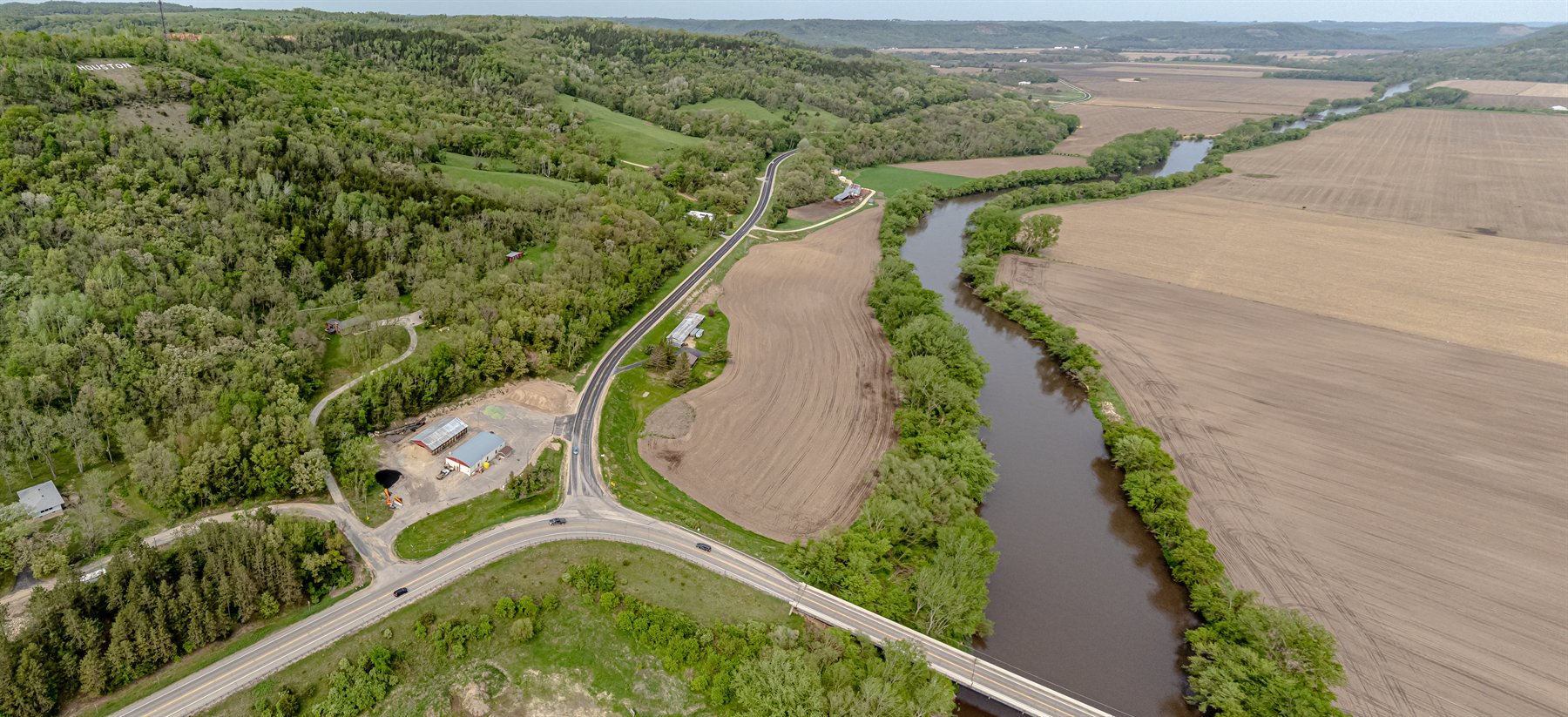
Launch at the Rushford carry-in and finish at the Houston carry-in near the Houston Nature Center. The route is friendly at workable flow, but it is long enough that low-water slowdowns and fresh wood can change the day substantially.
Put-in
Rushford carry-in access (Historic Depot area) Open mapThe best-known parking is at the Rushford Historic Depot lot and the Houston Nature Center lot, so expect a short walk or carry rather than a pure drive-to-water launch at both ends.
Take-out
Houston carry-in access (Houston Nature Center area) Open mapHouston Nature Center confirms ample parking at the trailhead, but still check local event activity before counting on the lot feeling empty.
Pulling access map tiles. Usually under 5 seconds.
Access caveats
- The best-known parking is at the Rushford Historic Depot lot and the Houston Nature Center lot, so expect a short walk or carry rather than a pure drive-to-water launch at both ends.
- Houston Nature Center confirms ample parking at the trailhead, but still check local event activity before counting on the lot feeling empty.
- Look at the Houston exit before launching if you have not used it before, because town-side trail and parking landmarks are easier to recognize from shore than from mid-river.
Watch for
- Low-water riffles and slower progress when the Houston gauge is near the floor.
- Fresh sweepers, strainers, or debris after rain.
- Long-mileage fatigue and cold-water exposure outside midsummer.
Route gallery
See this route on the water
Photos help show what the access looks like and what the route actually feels like on the water.
Sources
Check the data behind today's call.
Use this section when the page shows stale data, limited confidence, or a call you want to verify before driving.
Why this score Today's data confidence is checking
Data confidence mostly comes down to three things: how direct the gauge is, how clear the range is, and how fresh the data is.
- Checking data confidence notes.
- Checking data confidence cautions.
Outlook Tomorrow and weekend
This is a cautious early look. If the data is too thin, we leave it out.
Waiting on forecast.
Waiting on forecast.
Data behind the score Gauge, thresholds, and timing
These are the live readings and threshold notes behind today's score.
| Gauge site | Root River near Houston, MN |
| Discharge | Checking |
| Gauge height | Checking |
| 24h trend | Checking |
| 24h change | Checking |
| Current band | Checking |
| Rain last 24h | Checking |
| Rain last 72h | Checking |
| Air temp | Checking |
| Water temp | Checking |
| Wind | Checking |
| Gusts | Checking |
| Rain timing | Checking |
| Ideal range | Needs paddler reports |
| Known low-water floor | 300 cfs |
| High threshold | Not calibrated yet |
| Data confidence behind the range | Partial source data |
| Gauge observed | Checking |
| Paddle Today updated | Checking |
| Main source behind this score | Conservative low-water floor from Root River near Houston official gauge context |
| Gauge source | Checking |
| Weather source | Checking |
| Rainfall source | Checking |
Notes What to know before you go
These notes cover the access details, route quirks, and source caveats most likely to matter once you get there.
- Official route context 15.1 river miles
MN DNR recommends Rushford to Houston as a full-day Root River trip, with Rushford carry-in access at river mile 33.8 and Houston carry-in access at river mile 18.7.
- Access support Rushford carry-in to Houston carry-in
The Root River Map 2 PDF names both water-trail endpoints, and the state-trail map gives parking guidance at the Rushford Historic Depot lot and Houston Nature Center lot.
- Trailhead amenities Parking, restrooms, campground support
The official Guide to Trail Towns says both Rushford and Houston offer canoe launch access plus parking and public restrooms, with campground support in each town.
- Route character Gentle to moderate flow
MN DNR describes this stretch as having gentle to moderate flow, with flat water greeting paddlers along much of the route, while noting that water level can vary substantially with rainfall.
- Official low-flow context Q90 = 270 cfs at Houston
MN DNR drought guidance uses 270 cfs at the Root River near Houston as the annual Q90 low-flow benchmark for the watershed. That is not a paddling threshold, but it does support keeping the app low-water floor conservative and close to the obvious low-flow zone.
- Conservative low-water floor 300 cfs
This is a cautious app floor, not a published paddling threshold. It is intentionally set just above obvious late-low-water conditions because the Houston gauge has route support but no official numeric paddling ladder.
Verify it yourself Check the source links
Use these links to double-check the gauge, route details, and access notes before you head out.
- MN DNR Root River overview
- MN DNR Root River segments and maps
- MN DNR Root River Map 2 PDF
- MN DNR Root River and Harmony-Preston Valley State Trail map
- MN DNR Guide to Trail Towns PDF
- Rushford Peterson Valley visitor info
- Houston Nature Center
- Houston Nature Center Root River Trail access
- MN DNR drought low-flow Q90 guidance PDF
- USGS 05385000 monitoring location
Paddler reports
Recent notes from paddlers
A few quick notes from people who were on this route recently.
Reports
Photos, paddler notes, and updates.
See what others have shared, then add a condition report, upload photos, or flag anything that needs fixing.
Share your trip
Keep exploring
More routes to check next
Compare another stretch on this river, or jump to nearby options before you pick a plan.
Quick answers
Root River paddling FAQ
What water level is good for paddling Root River?
Paddle Today watches Root River near Houston, MN and uses 300 cfs as the conservative low-water floor for this route. The ideal range still needs more paddler reports.
Where does this Root River route start and end?
This route starts at Rushford carry-in access (Historic Depot area) and ends at Houston carry-in access (Houston Nature Center area), about 15.1 mi on the water.
Is this Root River route good for beginners?
This is listed as an easy route, but conditions still matter. Check today's score, water level, weather, and access notes before you go.
Flag a change
See something outdated?
Access, hazards, wood, and shuttle details change. Send a quick correction if something looks off.