See all 5 routes on Upper Iowa River
Iowa | Northeast Iowa
Upper Iowa River
Cattle Creek Road to Bluffton Fir Stand Access
Check current paddling conditions for this Upper Iowa River route, including water level, recent gauge trend, weather, and route details.
Route snapshot
Loading the route snapshot. This usually takes a few seconds.
Today
Get the answer fast, then scan the route.
Start with the verdict, current conditions, route plan, and quick facts before you commit to the drive.
Today's conditions
Gauge
Recent trend
Checking preferred range.
Checking trend.
Gauge source
-- Checking timestampMN DNR provides the current paddling level here, but not chart-ready recent samples.
Weather
Best window today
Checking weather.
Today by hour
Short-route forecast
Checking the next several hours.
Quick facts
Plan
Dial in the shuttle, distance, and access.
Use this section once the route looks viable and you need to turn it into an actual trip plan.
Access plan
Access, shuttle, and map
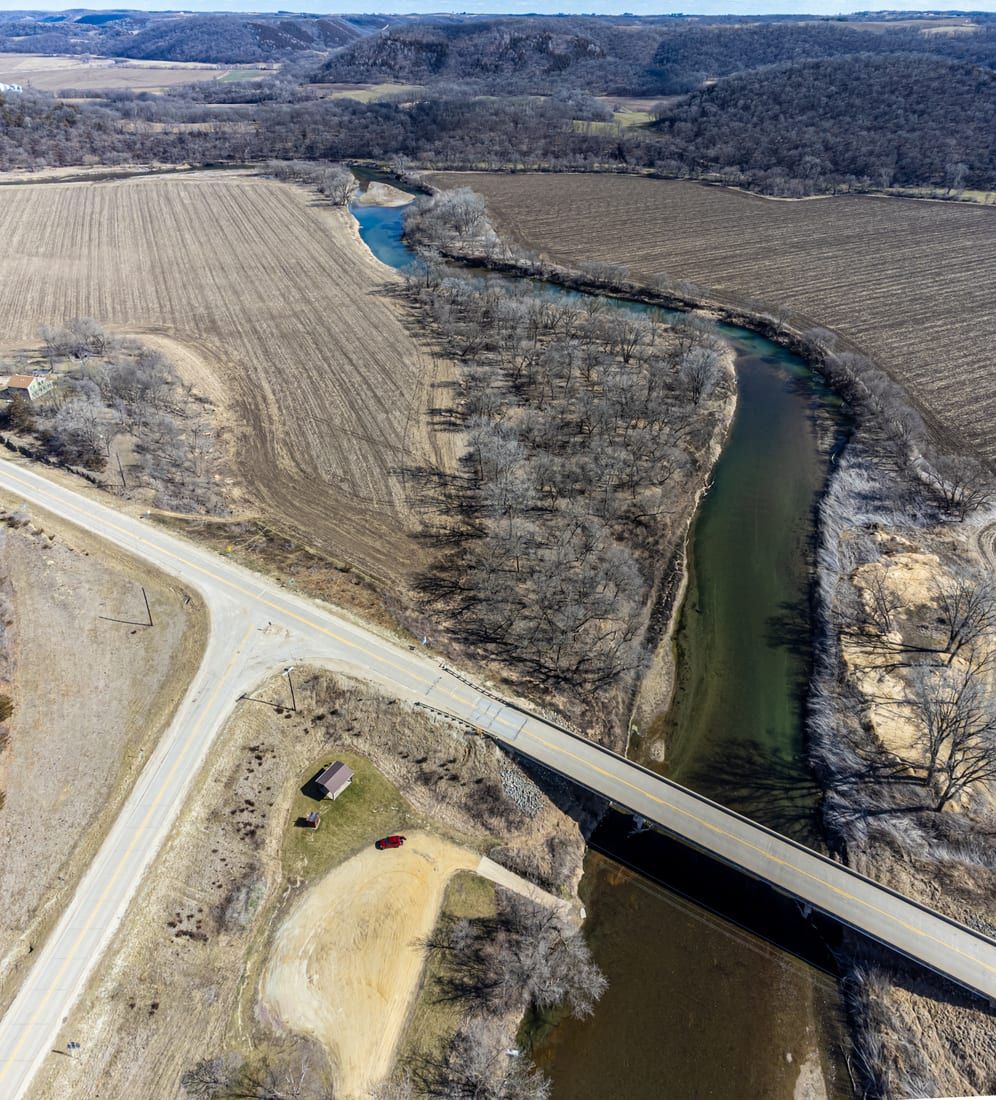
Launch at the Cattle Creek Road / Daley Bridge access area and take out at the public Bluffton Fir Stand / W20 canoe ramp after Chimney Rock, Bluffton Palisades, clear riffles, and the busiest scenic core of the Upper Iowa.
Put-in
Cattle Creek Road / Daley Bridge canoe access area Open mapThe Cattle Creek bridge/access area has changed since older trip reports, so confirm current parking and the launch path before unloading.
Take-out
Bluffton Fir Stand Access / Bluffton Road-W20 canoe ramp Open mapThe Bluffton-area take-out is deliberately downstream of the private campground launches so paddlers keep the final bluff section and finish at the public W20 / Bluffton Fir Stand access.
Pulling access map tiles. Usually under 5 seconds.
Access caveats
- The Cattle Creek bridge/access area has changed since older trip reports, so confirm current parking and the launch path before unloading.
- The Bluffton-area take-out is deliberately downstream of the private campground launches so paddlers keep the final bluff section and finish at the public W20 / Bluffton Fir Stand access.
- Summer weekends can be crowded with liveries, tubes, campground traffic, and limited parking patience at the access points.
Watch for
- Scraping in riffles near or below 150 cfs at the Bluffton gauge.
- Pushy current at roughly 700 cfs and above, plus faster consequences around wood, bridge approaches, and crowded landings.
- Minor Class I riffles, strainers after storms, cold-water exposure outside midsummer, and private-bank boundaries along the corridor.
Route gallery
See this route on the water
Photos help show what the access looks like and what the route actually feels like on the water.
Sources
Check the data behind today's call.
Use this section when the page shows stale data, limited confidence, or a call you want to verify before driving.
Why this score Today's data confidence is checking
Data confidence mostly comes down to three things: how direct the gauge is, how clear the range is, and how fresh the data is.
- Checking data confidence notes.
- Checking data confidence cautions.
Outlook Tomorrow and weekend
This is a cautious early look. If the data is too thin, we leave it out.
Waiting on forecast.
Waiting on forecast.
Data behind the score Gauge, thresholds, and timing
These are the live readings and threshold notes behind today's score.
| Gauge site | Upper Iowa River at Bluffton, IA |
| Discharge | Checking |
| Gauge height | Checking |
| 24h trend | Checking |
| 24h change | Checking |
| Current band | Checking |
| Rain last 24h | Checking |
| Rain last 72h | Checking |
| Air temp | Checking |
| Water temp | Checking |
| Wind | Checking |
| Gusts | Checking |
| Rain timing | Checking |
| Target band | 200 cfs to 500 cfs |
| Low threshold | 150 cfs |
| High threshold | 700 cfs |
| Data confidence behind the range | Local route guidance |
| Gauge observed | Checking |
| Paddle Today updated | Checking |
| Main source behind this score | Wisconsin River Trips Upper Iowa River Bluffton gauge guidance |
| Gauge source | Checking |
| Weather source | Checking |
| Rainfall source | Checking |
Notes What to know before you go
These notes cover the access details, route quirks, and source caveats most likely to matter once you get there.
- Official access sequence Cattle Creek to Bluffton Fir Stand Access
The Upper Iowa River Paddler's Guide lists the Kendallville-to-Bluffton segment access sequence and places Bluffton Fir Stand Access at river mile 73.4, downstream of Cattle Creek, Chimney Rock, and Bluffton Bluff Access.
- Published route report Cattle Creek Road Bridge to Bluffton Road/W20 Canoe Ramp
Wisconsin River Trips documents this route as a 9.7-mile Upper Iowa trip and calls out the Cattle Creek Road put-in and public canoe launch just downstream from Bluffton Road / W20.
- Target range About 200 to 500 cfs
Wisconsin River Trips reports 305 cfs at Bluffton as more than plenty, treats 200 cfs as low, and says lower water favors clarity while still avoiding the scrape-heavy floor.
- Low-water floor 150 cfs
The same route report describes 150 cfs at Bluffton as scrape-prone, while noting paddlers still regularly run below that level.
- High-water ceiling 700+ cfs
Wisconsin River Trips estimates that 700 cfs and above on the Bluffton gauge would be too pushy for this route.
- Direct gauge USGS 05387440
USGS operates Upper Iowa River at Bluffton, IA, with current and historical observations in the same Bluffton route corridor.
- Put-in support Cattle Creek Road / Daley Bridge access area
Wisconsin River Trips describes the Cattle Creek Road bridge as a busy access with roadside parking and a launch ramp, and The Gazette identifies the same area as Daley Bridge Canoe Access at Cattle Creek Road.
- Take-out support Bluffton Fir Stand Access / Bluffton Road-W20 canoe ramp
The Upper Iowa River Paddler's Guide lists Bluffton Fir Stand Access and the route report describes a public canoe launch with parking just downstream from Bluffton Road / W20.
Verify it yourself Check the source links
Use these links to double-check the gauge, route details, and access notes before you head out.
Paddler reports
Recent notes from paddlers
A few quick notes from people who were on this route recently.
Reports
Photos, paddler notes, and updates.
See what others have shared, then add a condition report, upload photos, or flag anything that needs fixing.
Share your trip
Keep exploring
More routes to check next
Compare another stretch on this river, or jump to nearby options before you pick a plan.
Quick answers
Upper Iowa River paddling FAQ
What water level is good for paddling Upper Iowa River?
Paddle Today watches Upper Iowa River at Bluffton, IA and treats 200 cfs to 500 cfs as the target band for this route, with weather and recent trend included in the final score.
Where does this Upper Iowa River route start and end?
This route starts at Cattle Creek Road / Daley Bridge canoe access area and ends at Bluffton Fir Stand Access / Bluffton Road-W20 canoe ramp, about 9.7 mi on the water.
Is this Upper Iowa River route good for beginners?
This is listed as an easy route, but conditions still matter. Check today's score, water level, weather, and access notes before you go.
Flag a change
See something outdated?
Access, hazards, wood, and shuttle details change. Send a quick correction if something looks off.