See all 5 routes on Upper Iowa River
Iowa | Northeast Iowa
Upper Iowa River
Malanaphy Springs to Trout Run Park
Check current paddling conditions for this Upper Iowa River route, including water level, recent gauge trend, weather, and route details.
Route snapshot
Loading the route snapshot. This usually takes a few seconds.
Today
Get the answer fast, then scan the route.
Start with the verdict, current conditions, route plan, and quick facts before you commit to the drive.
Today's conditions
Gauge
Recent trend
Checking preferred range.
Checking trend.
Gauge source
-- Checking timestampMN DNR provides the current paddling level here, but not chart-ready recent samples.
Weather
Best window today
Checking weather.
Today by hour
Short-route forecast
Checking the next several hours.
Quick facts
Plan
Dial in the shuttle, distance, and access.
Use this section once the route looks viable and you need to turn it into an actual trip plan.
Access plan
Access, shuttle, and map
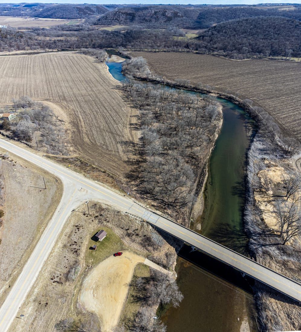
Launch at the Malanaphy Springs / Bluffton Road bridge area and take out at Trout Run Park for an Upper Iowa route that starts rural, passes Chattahoochie Park and Decorah bluffs, and finishes at a city park with boat access.
Put-in
Malanaphy Springs / Bluffton Road bridge access Open mapMalanaphy Springs access is usable but limited; expect a small lot, a muddy or steep carry, and conflicts with hikers on busy days.
Take-out
Trout Run Park boat access Open mapIf the Malanaphy lot is full, the downstream Pole Line Road bridge access is the cleaner fallback, but it shortens the route.
Pulling access map tiles. Usually under 5 seconds.
Access caveats
- Malanaphy Springs access is usable but limited; expect a small lot, a muddy or steep carry, and conflicts with hikers on busy days.
- If the Malanaphy lot is full, the downstream Pole Line Road bridge access is the cleaner fallback, but it shortens the route.
- Trout Run Park is the planned take-out because it has published boat access and parking where Trout Run enters the Upper Iowa River.
Watch for
- Scraping and dragging in riffles when the Bluffton gauge is near or below 125 cfs.
- Class I riffles, shallow rock, bridge approaches, and city-park traffic through Decorah.
- Fresh strainers after storms, faster current on rising water, cold spring inflows, and private-bank boundaries along the corridor.
Route gallery
See this route on the water
Photos help show what the access looks like and what the route actually feels like on the water.
Sources
Check the data behind today's call.
Use this section when the page shows stale data, limited confidence, or a call you want to verify before driving.
Why this score Today's data confidence is checking
Data confidence mostly comes down to three things: how direct the gauge is, how clear the range is, and how fresh the data is.
- Checking data confidence notes.
- Checking data confidence cautions.
Outlook Tomorrow and weekend
This is a cautious early look. If the data is too thin, we leave it out.
Waiting on forecast.
Waiting on forecast.
Data behind the score Gauge, thresholds, and timing
These are the live readings and threshold notes behind today's score.
| Gauge site | Upper Iowa River at Bluffton, IA |
| Discharge | Checking |
| Gauge height | Checking |
| 24h trend | Checking |
| 24h change | Checking |
| Current band | Checking |
| Rain last 24h | Checking |
| Rain last 72h | Checking |
| Air temp | Checking |
| Water temp | Checking |
| Wind | Checking |
| Gusts | Checking |
| Rain timing | Checking |
| Ideal range | Needs paddler reports |
| Known low-water floor | 125 cfs |
| High threshold | Not calibrated yet |
| Data confidence behind the range | Local route guidance |
| Gauge observed | Checking |
| Paddle Today updated | Checking |
| Main source behind this score | Miles Paddled Upper Iowa River V minimum-flow note |
| Gauge source | Checking |
| Weather source | Checking |
| Rainfall source | Checking |
Notes What to know before you go
These notes cover the access details, route quirks, and source caveats most likely to matter once you get there.
- Published route report Malanaphy Springs to Trout Run Park
Miles Paddled documents this as an 11-mile Upper Iowa River route from the Bluffton Road bridge / Malanaphy Springs access area to Trout Run Park in Decorah.
- Low-water floor 125 cfs
Miles Paddled ran the route at 75 cfs on the Bluffton gauge, called that too low to recommend, and says 125 cfs is the minimum to avoid the worst scraping.
- Direct gauge USGS 05387440
USGS operates Upper Iowa River at Bluffton, IA, a live same-river gauge in the same Bluffton-to-Decorah corridor and the gauge cited by the route report.
- Official access sequence Malanaphy, Chattahoochie, Trout Run
The Upper Iowa River Paddler's Guide identifies Malanaphy Springs Access, Chattahoochie Park Access, and Trout Run Park Access in the downstream Decorah water-trail sequence.
- Take-out support Trout Run Park boat access
Travel Iowa describes Trout Run Park on the east edge of Decorah, where Trout Run enters the Upper Iowa River, and says the park provides boat access and parking.
- Access caveat Limited Malanaphy parking
Miles Paddled describes the Malanaphy Springs / Bluffton Road river access as doable but muddy with limited parking, and suggests using the downstream Pole Line Road bridge if the small lot is full.
Verify it yourself Check the source links
Use these links to double-check the gauge, route details, and access notes before you head out.
Paddler reports
Recent notes from paddlers
A few quick notes from people who were on this route recently.
Reports
Photos, paddler notes, and updates.
See what others have shared, then add a condition report, upload photos, or flag anything that needs fixing.
Share your trip
Keep exploring
More routes to check next
Compare another stretch on this river, or jump to nearby options before you pick a plan.
Quick answers
Upper Iowa River paddling FAQ
What water level is good for paddling Upper Iowa River?
Paddle Today watches Upper Iowa River at Bluffton, IA and uses 125 cfs as the conservative low-water floor for this route. The ideal range still needs more paddler reports.
Where does this Upper Iowa River route start and end?
This route starts at Malanaphy Springs / Bluffton Road bridge access and ends at Trout Run Park boat access, about 11 mi on the water.
Is this Upper Iowa River route good for beginners?
This is listed as an easy route, but conditions still matter. Check today's score, water level, weather, and access notes before you go.
Flag a change
See something outdated?
Access, hazards, wood, and shuttle details change. Send a quick correction if something looks off.