Minnesota | Twin Cities West Metro
South Fork Crow River
Rick Johnson Park to Lake Rebecca Park Reserve
Check current paddling conditions for this South Fork Crow River route, including water level, recent gauge trend, weather, and route details.
Route snapshot
Loading the route snapshot. This usually takes a few seconds.
Today
Get the answer fast, then scan the route.
Start with the verdict, current conditions, route plan, and quick facts before you commit to the drive.
Today's conditions
Gauge
Recent trend
Checking preferred range.
Checking trend.
Gauge source
-- Checking timestampMN DNR provides the current paddling level here, but not chart-ready recent samples.
Weather
Best window today
Checking weather.
Today by hour
Short-route forecast
Checking the next several hours.
Quick facts
Plan
Dial in the shuttle, distance, and access.
Use this section once the route looks viable and you need to turn it into an actual trip plan.
Access plan
Access, shuttle, and map
Start below the Watertown dam at Rick Johnson Park and finish at the Lake Rebecca Crow River carry-in. This is the DNR-recommended full-day South Fork Crow trip through Delano.
Put-in
South Fork Crow River boat landing / Rick Johnson Park trailer access Open mapThe put-in is below the Watertown dam; do not launch upstream of the dam or improvise around dam infrastructure.
Take-out
Lake Rebecca Park Reserve Crow River carry-in access Open mapLake Rebecca is a large park reserve, so identify the Crow River carry-in and parking area before committing to the shuttle.
Pulling access map tiles. Usually under 5 seconds.
Access caveats
- The put-in is below the Watertown dam; do not launch upstream of the dam or improvise around dam infrastructure.
- Lake Rebecca is a large park reserve, so identify the Crow River carry-in and parking area before committing to the shuttle.
- The route starts on the South Fork and finishes on the North Fork near the confluence, which can be confusing if you only skim the map.
Watch for
- Fallen trees, submerged snags, and overhanging branches on wooded bends.
- Faster current after significant rainfall even when the river is usually gentle.
- Private shoreland; stop only at public landings or clearly legal sites.
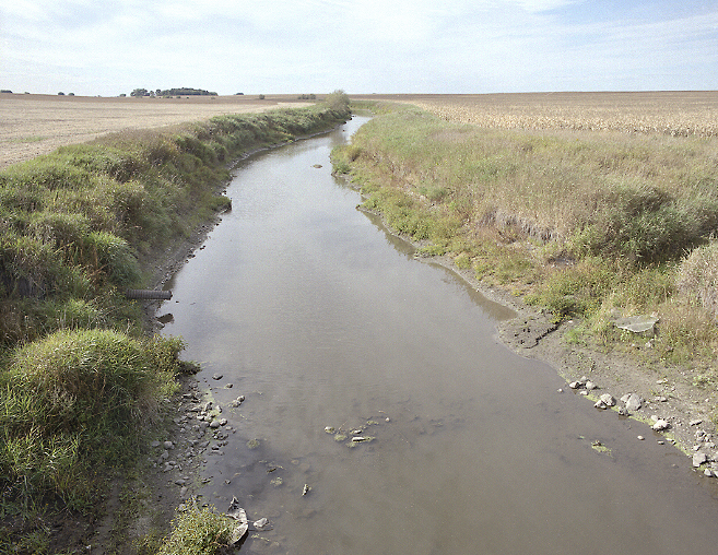
Route gallery
See this route on the water
Photos help show what the access looks like and what the route actually feels like on the water.
Sources
Check the data behind today's call.
Use this section when the page shows stale data, limited confidence, or a call you want to verify before driving.
Why this score Today's data confidence is checking
Data confidence mostly comes down to three things: how direct the gauge is, how clear the range is, and how fresh the data is.
- Checking data confidence notes.
- Checking data confidence cautions.
Outlook Tomorrow and weekend
This is a cautious early look. If the data is too thin, we leave it out.
Waiting on forecast.
Waiting on forecast.
Data behind the score Gauge, thresholds, and timing
These are the live readings and threshold notes behind today's score.
| Gauge site | South Fork Crow River at Delano, Bridge Ave |
| Discharge | Checking |
| Gauge height | Checking |
| 24h trend | Checking |
| 24h change | Checking |
| Current band | Checking |
| Rain last 24h | Checking |
| Rain last 72h | Checking |
| Air temp | Checking |
| Water temp | Checking |
| Wind | Checking |
| Gusts | Checking |
| Rain timing | Checking |
| Target band | 200 cfs to 600 cfs |
| Low threshold | 26 cfs |
| High threshold | 800 cfs |
| Data confidence behind the range | Official data source |
| Gauge observed | Checking |
| Paddle Today updated | Checking |
| Main source behind this score | MN DNR river-level interpretation bands for South Fork Crow River at Delano |
| Gauge source | Checking |
| Weather source | Checking |
| Rainfall source | Checking |
Notes What to know before you go
These notes cover the access details, route quirks, and source caveats most likely to matter once you get there.
- DNR bands 26 / 200-600 / 800 cfs
MN DNR interprets the Delano reading as Scrapable below 26 cfs, Low from 26 to 200, Medium from 200 to 600, High from 600 to 800, and Very High above 800.
- Recommended trip 14.3 river miles
MN DNR recommends Rick Johnson Park trailer access to Lake Rebecca Regional Park carry-in access as the South Fork Crow day trip.
- Gauge placement Bridge Avenue in Delano
The DNR South Fork Crow map places the river-level gauge at Bridge Avenue in Delano, directly on the recommended route corridor.
- Take-out support Crow River carry-in access
Three Rivers Park District says Lake Rebecca Park Reserve offers carry-in access to the Crow River.
- Primary cautions Dam start, wood, private shoreland
The DNR map places the put-in below the Watertown dam and warns paddlers to watch river levels, avoid dead and overhanging trees, and stay off private property.
Verify it yourself Check the source links
Use these links to double-check the gauge, route details, and access notes before you head out.
Paddler reports
Recent notes from paddlers
A few quick notes from people who were on this route recently.
Reports
Photos, paddler notes, and updates.
See what others have shared, then add a condition report, upload photos, or flag anything that needs fixing.
Share your trip
Keep exploring
More routes to check next
Compare another stretch on this river, or jump to nearby options before you pick a plan.
More in Minnesota
All 46 routesNearby routes by distance
Quick answers
South Fork Crow River paddling FAQ
What water level is good for paddling South Fork Crow River?
Paddle Today watches South Fork Crow River at Delano, Bridge Ave and treats 200 cfs to 600 cfs as the target band for this route, with weather and recent trend included in the final score.
Where does this South Fork Crow River route start and end?
This route starts at South Fork Crow River boat landing / Rick Johnson Park trailer access and ends at Lake Rebecca Park Reserve Crow River carry-in access, about 14.3 mi on the water.
Is this South Fork Crow River route good for beginners?
This is listed as a moderate route. Expect more planning than an easy float, and use the live score, route notes, and source links before committing.
Flag a change
See something outdated?
Access, hazards, wood, and shuttle details change. Send a quick correction if something looks off.