See all 6 routes on Big Piney River
Missouri | Missouri Ozarks
Big Piney River
East Gate Access to Bookers Bend Access
Check current paddling conditions for this Big Piney River route, including water level, recent gauge trend, weather, and route details.
Route snapshot
Loading the route snapshot. This usually takes a few seconds.
Today
Get the answer fast, then scan the route.
Start with the verdict, current conditions, route plan, and quick facts before you commit to the drive.
Today's conditions
Gauge
Recent trend
Checking preferred range.
Checking trend.
Gauge source
-- Checking timestampMN DNR provides the current paddling level here, but not chart-ready recent samples.
Weather
Best window today
Checking weather.
Today by hour
Short-route forecast
Checking the next several hours.
Quick facts
Plan
Dial in the shuttle, distance, and access.
Use this section once the route looks viable and you need to turn it into an actual trip plan.
Access plan
Access, shuttle, and map
Launch at Forest Service East Gate Access and take out at Forest Service Bookers Bend Access for the official 11-mile Big Piney day float. Use the Big Piney USGS gauge as a same-river level check, but keep the decision conservative because the level model is community-calibrated.
Put-in
East Gate Access Open mapEast Gate and Bookers Bend are small Forest Service gravel boat/canoe accesses with limited parking for about three vehicles with trailers.
Take-out
Bookers Bend Access Open mapBookers Bend has no restroom or potable water. East Gate also lists no restroom or potable water.
Pulling access map tiles. Usually under 5 seconds.
Access caveats
- East Gate and Bookers Bend are small Forest Service gravel boat/canoe accesses with limited parking for about three vehicles with trailers.
- Bookers Bend has no restroom or potable water. East Gate also lists no restroom or potable water.
- Most land along the lower Big Piney corridor is private. Stay with public accesses and clearly legal gravel-bar stops rather than climbing banks or using private land.
- The Forest Service notes that there are no outfitters authorized to operate at these locations, so private shuttle logistics need to be settled before launch.
Watch for
- Shallow riffles, dragging, and a slower 11-mile day when the Big Piney gauge is below the MoHERP low-water floor.
- Runs, riffles, pools, gravel-bottom shoals, and occasional murky water after rain.
- Rapid rises after storms, fresh wood, harder landings, and no defended high-water cutoff in the current model.
- Small gravel ramps, limited parking, motorized users, fishing traffic, and private shorelines between the accesses.
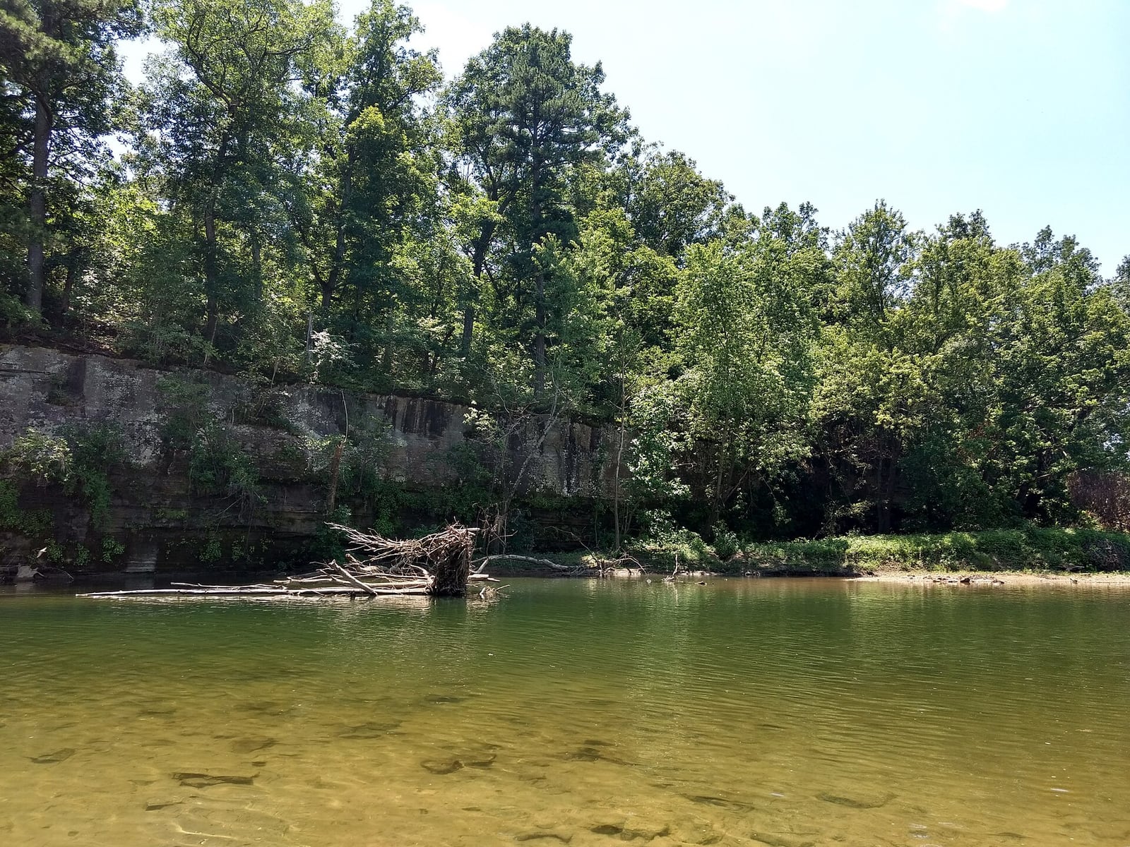
Route gallery
See this route on the water
Photos help show what the access looks like and what the route actually feels like on the water.
Sources
Check the data behind today's call.
Use this section when the page shows stale data, limited confidence, or a call you want to verify before driving.
Why this score Today's data confidence is checking
Data confidence mostly comes down to three things: how direct the gauge is, how clear the range is, and how fresh the data is.
- Checking data confidence notes.
- Checking data confidence cautions.
Outlook Tomorrow and weekend
This is a cautious early look. If the data is too thin, we leave it out.
Waiting on forecast.
Waiting on forecast.
Data behind the score Gauge, thresholds, and timing
These are the live readings and threshold notes behind today's score.
| Gauge site | Big Piney River near Big Piney, MO |
| Discharge | Checking |
| Gauge height | Checking |
| 24h trend | Checking |
| 24h change | Checking |
| Current band | Checking |
| Rain last 24h | Checking |
| Rain last 72h | Checking |
| Air temp | Checking |
| Water temp | Checking |
| Wind | Checking |
| Gusts | Checking |
| Rain timing | Checking |
| Ideal range | Needs paddler reports |
| Known low-water floor | 309 cfs |
| High threshold | Not calibrated yet |
| Data confidence behind the range | Local route guidance |
| Gauge observed | Checking |
| Paddle Today updated | Checking |
| Main source behind this score | Rivers.MOHERP Big Piney River gauge bands at Big Piney |
| Gauge source | Checking |
| Weather source | Checking |
| Rainfall source | Checking |
Notes What to know before you go
These notes cover the access details, route quirks, and source caveats most likely to matter once you get there.
- Official route shape East Gate to Bookers Bend, 11 mi
The Forest Service East Gate page says paddlers can take a short 3-mile trip to Crossroads or a longer 11-mile trip to Bookers Bend.
- Public put-in East Gate Access
The Forest Service lists East Gate as an open small gravel boat/canoe access for the Big Piney, with coordinates, parking for three vehicles with trailers, and no fee.
- Public take-out Bookers Bend Access
The Forest Service lists Bookers Bend as an open small gravel boat/canoe access for the Big Piney, with coordinates, parking for three vehicles with trailers, no fee, and no restroom or potable water.
- Live direct gauge USGS 06930000
USGS Big Piney River near Big Piney showed same-day May 30, 2026 discharge and gage-height observations, with 251 cfs and 2.79 ft at 08:00 CDT during review.
- Low-water floor 309 cfs minimum-only
Rivers.MOHERP refreshed the Big Piney gauge on May 30, 2026 and showed the river rated Poor at 251 cfs, with the Low band beginning at 309 cfs and Good beginning at 519 cfs. Paddle Today uses only the low-water floor and does not infer an ideal range.
- River character Spring-fed, gravel-bottom Ozark river
The Forest Service says the Big Piney is spring fed, usually floatable year-round unless particularly dry, and has runs, riffles, pools, gravel bottom, limestone bluffs, and pine-topped scenery.
- Access and high-water cautions Private land and rapid rises
The Forest Service warns that most land along the lower Bookers Bend stretch is private and says the river can rise rapidly; use public accesses and legal stops only.
Verify it yourself Check the source links
Use these links to double-check the gauge, route details, and access notes before you head out.
Paddler reports
Recent notes from paddlers
A few quick notes from people who were on this route recently.
Reports
Photos, paddler notes, and updates.
See what others have shared, then add a condition report, upload photos, or flag anything that needs fixing.
Share your trip
Keep exploring
More routes to check next
Compare another stretch on this river, or jump to nearby options before you pick a plan.
Quick answers
Big Piney River paddling FAQ
What water level is good for paddling Big Piney River?
Paddle Today watches Big Piney River near Big Piney, MO and uses 309 cfs as the conservative low-water floor for this route. The ideal range still needs more paddler reports.
Where does this Big Piney River route start and end?
This route starts at East Gate Access and ends at Bookers Bend Access, about 11 mi on the water.
Is this Big Piney River route good for beginners?
This is listed as an easy route, but conditions still matter. Check today's score, water level, weather, and access notes before you go.
Flag a change
See something outdated?
Access, hazards, wood, and shuttle details change. Send a quick correction if something looks off.