See all 2 routes on Mississippi River
Minnesota | Twin Cities
Mississippi River
East River Flats to Hidden Falls Regional Park
Check current paddling conditions for this Mississippi River route, including water level, recent gauge trend, weather, and route details.
Route snapshot
Loading the route snapshot. This usually takes a few seconds.
Today
Get the answer fast, then scan the route.
Start with the verdict, current conditions, route plan, and quick facts before you commit to the drive.
Today's conditions
Gauge
Recent trend
Checking preferred range.
Checking trend.
Gauge source
-- Checking timestampMN DNR provides the current paddling level here, but not chart-ready recent samples.
Weather
Best window today
Checking weather.
Today by hour
Short-route forecast
Checking the next several hours.
Quick facts
Plan
Dial in the shuttle, distance, and access.
Use this section once the route looks viable and you need to turn it into an actual trip plan.
Access plan
Access, shuttle, and map
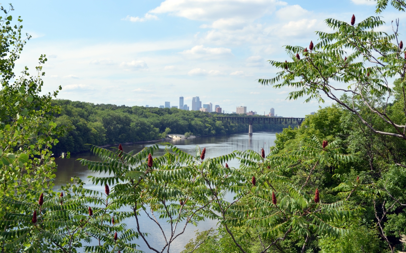
Launch at East River Flats and finish at Hidden Falls for the official DNR Twin Cities Mississippi trip. The route is short on paper, but the real decisions are current, wakes, wind, and Lock and Dam 1 handling.
Put-in
East River Flats Park Open mapDNR explicitly names East River Flats Park as the launch, but the launch logistics there are still less clearly documented than the Hidden Falls take-out. Check the access on arrival instead of assuming a trailer-style ramp.
Take-out
Hidden Falls Regional Park boat launch Open mapHidden Falls has posted park hours and can close roads or amenities during flooding, restoration, or other conditions.
Pulling access map tiles. Usually under 5 seconds.
Access caveats
- DNR explicitly names East River Flats Park as the launch, but the launch logistics there are still less clearly documented than the Hidden Falls take-out. Check the access on arrival instead of assuming a trailer-style ramp.
- Hidden Falls has posted park hours and can close roads or amenities during flooding, restoration, or other conditions.
- Lock and Dam 1 is not a full-time recreational lock. USACE lists recreation lockage for Saturdays, Sundays, major holidays, and Monday/Friday afternoons, says weekday hours can change, and tells boaters to contact lock staff on VHF channel 14, by the pull cord, or at 651-290-5919.
Watch for
- Swift current and large wakes from larger river traffic.
- Lock and Dam 1 procedure when the lock is operating; be at the lock at least 30 minutes before posted closure.
- A 1.40-mile unsigned Lock and Dam 1 portage if the lock is unavailable. NPS places the take-out on river right about one-third mile upstream of the Ford Bridge and the put-in at the Minnehaha Creek mouth.
- Do not use Minnehaha Creek itself as a shortcut around the dam; NPS warns of down trees, rapids, and hazards in the creek.
- Wind, floating debris, and muddy landings after recent weather.
Route gallery
See this route on the water
Photos help show what the access looks like and what the route actually feels like on the water.
Sources
Check the data behind today's call.
Use this section when the page shows stale data, limited confidence, or a call you want to verify before driving.
Why this score Today's data confidence is checking
Data confidence mostly comes down to three things: how direct the gauge is, how clear the range is, and how fresh the data is.
- Checking data confidence notes.
- Checking data confidence cautions.
Outlook Tomorrow and weekend
This is a cautious early look. If the data is too thin, we leave it out.
Waiting on forecast.
Waiting on forecast.
Data behind the score Gauge, thresholds, and timing
These are the live readings and threshold notes behind today's score.
| Gauge site | Mississippi River at St. Paul, MN |
| Discharge | Checking |
| Gauge height | Checking |
| 24h trend | Checking |
| 24h change | Checking |
| Current band | Checking |
| Rain last 24h | Checking |
| Rain last 72h | Checking |
| Air temp | Checking |
| Water temp | Checking |
| Wind | Checking |
| Gusts | Checking |
| Rain timing | Checking |
| Target band | 6,000 cfs to 30,000 cfs |
| Low threshold | 2,000 cfs |
| High threshold | 40,000 cfs |
| Data confidence behind the range | Official data source |
| Gauge observed | Checking |
| Paddle Today updated | Checking |
| Main source behind this score | MN DNR river-level interpretation bands for Mississippi River at St. Paul |
| Gauge source | Checking |
| Weather source | Checking |
| Rainfall source | Checking |
Notes What to know before you go
These notes cover the access details, route quirks, and source caveats most likely to matter once you get there.
- DNR bands 2,000 / 6,000 / 30,000 / 40,000 cfs
MN DNR interprets the St. Paul reading as Scrapable below 2,000 cfs, Low from 2,000 to 6,000, Medium from 6,000 to 30,000, High from 30,000 to 40,000, and Very High above 40,000.
- Recommended trip 5 river miles / about 2 hours
MN DNR explicitly recommends East River Flats Park to Hidden Falls Park as the first of its two Mississippi River recommended paddling trips.
- Route character Swift current, large wakes, navigational lock
DNR says this stretch requires a moderate degree of paddling skill because of swift current and large wakes from large boats and barges, and tells paddlers to follow navigational lock procedures.
- Take-out support Hidden Falls boat launch and posted hours
Saint Paul identifies Hidden Falls Regional Park as a Mississippi River boat-launch site with north-entrance access, sunrise-to-10 p.m. hours, and closures possible during flooding or other conditions.
- Lock and Dam 1 backup plan Call ahead; portage is 1.40 miles
USACE lists recreational lockage at Lock and Dam 1 for Saturdays, Sundays, major holidays, and Monday/Friday afternoons, with weekday availability subject to change. Contact lock staff on VHF channel 14, by pull cord, or at 651-290-5919; NPS advises using the lock when operational because the alternate portage is long, new as of September 2025, and not yet signed.
- Lock and Dam 1 portage River-right take-out to Minnehaha Creek mouth
NPS describes the unsigned 1.40-mile Ford Dam portage as starting at a small natural gravel beach on river right about one-third mile upstream of the Ford Bridge, climbing switchbacks to the bluff trail, then descending through Minnehaha Falls Park to put in at the Minnehaha Creek confluence. Do not paddle Minnehaha Creek; NPS warns of down trees, rapids, and hazards there.
Verify it yourself Check the source links
Use these links to double-check the gauge, route details, and access notes before you head out.
- MN DNR river levels
- MN DNR Mississippi River overview
- MN DNR recommended paddling trip: East River Flats to Hidden Falls
- MN DNR Mississippi River map 10 PDF
- Minneapolis Parks East River Flats Park
- Saint Paul Hidden Falls Regional Park
- NPS navigating portages, locks, and dams
- USACE Lock and Dam 1 lockage hours
- USGS 05331000 monitoring location
Paddler reports
Recent notes from paddlers
A few quick notes from people who were on this route recently.
Reports
Photos, paddler notes, and updates.
See what others have shared, then add a condition report, upload photos, or flag anything that needs fixing.
Share your trip
Keep exploring
More routes to check next
Compare another stretch on this river, or jump to nearby options before you pick a plan.
Quick answers
Mississippi River paddling FAQ
What water level is good for paddling Mississippi River?
Paddle Today watches Mississippi River at St. Paul, MN and treats 6,000 cfs to 30,000 cfs as the target band for this route, with weather and recent trend included in the final score.
Where does this Mississippi River route start and end?
This route starts at East River Flats Park and ends at Hidden Falls Regional Park boat launch, about 5 mi on the water.
Is this Mississippi River route good for beginners?
This is listed as a moderate route. Expect more planning than an easy float, and use the live score, route notes, and source links before committing.
Flag a change
See something outdated?
Access, hazards, wood, and shuttle details change. Send a quick correction if something looks off.