See all 6 routes on Big Piney River
Missouri | Missouri Ozarks
Big Piney River
Slabtown Recreation Area to Ross Access
Check current paddling conditions for this Big Piney River route, including water level, recent gauge trend, weather, and route details.
Route snapshot
Loading the route snapshot. This usually takes a few seconds.
Today
Get the answer fast, then scan the route.
Start with the verdict, current conditions, route plan, and quick facts before you commit to the drive.
Today's conditions
Gauge
Recent trend
Checking preferred range.
Checking trend.
Gauge source
-- Checking timestampMN DNR provides the current paddling level here, but not chart-ready recent samples.
Weather
Best window today
Checking weather.
Today by hour
Short-route forecast
Checking the next several hours.
Quick facts
Plan
Dial in the shuttle, distance, and access.
Use this section once the route looks viable and you need to turn it into an actual trip plan.
Access plan
Access, shuttle, and map
Launch at Forest Service Slabtown Recreation Area and take out at MDC Ross Access for a long lower Big Piney link. The route uses the Big Piney USGS gauge with a conservative low-water floor, but the mileage and shallow riffles make same-day judgment important.
Put-in
Slabtown Recreation Area Open mapSlabtown is a Forest Service access and camping area with a single-lane launch, limited boat-launch parking, vault toilet, picnic tables, and no potable water.
Take-out
Ross Access Open mapThe Forest Service warns the bottom of the Slabtown ramp can be shallow from gravel build-up and that the river at the launch can be swift moving.
Pulling access map tiles. Usually under 5 seconds.
Access caveats
- Slabtown is a Forest Service access and camping area with a single-lane launch, limited boat-launch parking, vault toilet, picnic tables, and no potable water.
- The Forest Service warns the bottom of the Slabtown ramp can be shallow from gravel build-up and that the river at the launch can be swift moving.
- MDC confirms Ross Access as public floating and fishing access with parking, but the coordinate is an OSM-derived slipway anchor paired with MDC access authority rather than an MDC survey coordinate.
- Private land borders portions of the Big Piney corridor. Stay with public accesses, lawful gravel-bar stops, and posted rules rather than climbing banks or using private land.
Watch for
- Long mileage and reduced daylight margin; low flows can turn the route into a very slow trip with dragging and portages.
- Narrower, shallower, riffly water between Slabtown and Ross, with long pools and limited public bailout options.
- Rapid rises after storms, murky water, fresh wood, strainers, swift launch current, and more difficult landings. The current model has no defended high-water cutoff.
- Limited services, limited cell coverage, rural shuttle roads, fishing traffic, and legal-camping boundaries if the group turns this into an overnight.
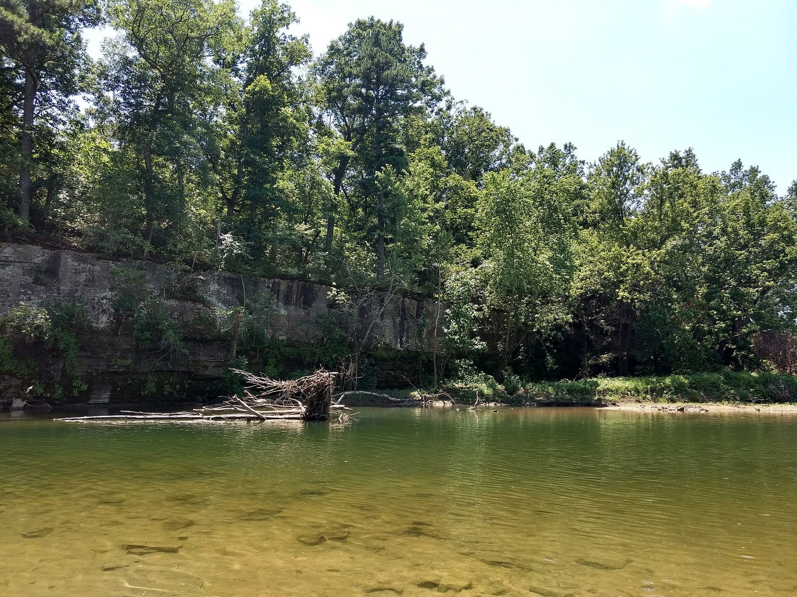
Route gallery
See this route on the water
Photos help show what the access looks like and what the route actually feels like on the water.
Sources
Check the data behind today's call.
Use this section when the page shows stale data, limited confidence, or a call you want to verify before driving.
Why this score Today's data confidence is checking
Data confidence mostly comes down to three things: how direct the gauge is, how clear the range is, and how fresh the data is.
- Checking data confidence notes.
- Checking data confidence cautions.
Outlook Tomorrow and weekend
This is a cautious early look. If the data is too thin, we leave it out.
Waiting on forecast.
Waiting on forecast.
Data behind the score Gauge, thresholds, and timing
These are the live readings and threshold notes behind today's score.
| Gauge site | Big Piney River near Big Piney, MO |
| Discharge | Checking |
| Gauge height | Checking |
| 24h trend | Checking |
| 24h change | Checking |
| Current band | Checking |
| Rain last 24h | Checking |
| Rain last 72h | Checking |
| Air temp | Checking |
| Water temp | Checking |
| Wind | Checking |
| Gusts | Checking |
| Rain timing | Checking |
| Ideal range | Needs paddler reports |
| Known low-water floor | 309 cfs |
| High threshold | Not calibrated yet |
| Data confidence behind the range | Local route guidance |
| Gauge observed | Checking |
| Paddle Today updated | Checking |
| Main source behind this score | Rivers.MOHERP Big Piney River gauge bands at Big Piney and exact Slabtown-to-Ross trip row |
| Gauge source | Checking |
| Weather source | Checking |
| Rainfall source | Checking |
Notes What to know before you go
These notes cover the access details, route quirks, and source caveats most likely to matter once you get there.
- Route mileage About 15.6 to 17 mi
Big Piney River Stream Team Watershed Association lists Slabtown to Six Crossings as mile 42.0 to 50.8 and Six Crossings to Ross Access as mile 50.8 to 57.6, while the MoHERP exact trip row records Slabtown to Ross Bridge as 17.0 miles.
- Public put-in Slabtown Recreation Area
The Forest Service describes Slabtown as a small access and camping area on the Big Piney with a boat launch, limited parking, vault toilet, picnic tables, and official coordinates.
- Public take-out Ross Access
MDC lists Ross Access as a public area that provides access for floating and fishing on the Big Piney River, with parking and directions from Duke.
- Take-out coordinate anchor 37.66414, -92.05157
Mapcarta / OpenStreetMap identifies the Ross-area MDC slipway near the access at this coordinate. Pair the coordinate with MDC access authority and follow signs and current ramp layout on arrival.
- Live direct gauge USGS 06930000
USGS Big Piney River near Big Piney showed same-day May 31, 2026 discharge and gage-height observations, including 395 cfs and 3.21 ft at 15:00 CDT during review.
- Low-water floor 309 cfs minimum-only
Rivers.MOHERP Big Piney gauge bands put the start of Low at 309 cfs. The app reuses this conservative floor from adjacent Big Piney routes and does not infer an ideal range or upper cutoff.
- Exact route evidence Slabtown to Ross Bridge row
Rivers.MOHERP includes an exact Slabtown-to-Ross Bridge row rated Good at 317 cfs / 2.93 ft, recorded as a combined two-day trip. That supports the gauge relationship but the app still warns that this is a long reach.
- Route character Narrower, shallower, riffly below Slabtown
The Forest Service says the Big Piney is usually floatable unless particularly dry and specifically notes that downriver from Slabtown the river is narrow and shallower, with multiple riffles, before widening below Ross Bridge.
Verify it yourself Check the source links
Use these links to double-check the gauge, route details, and access notes before you head out.
Paddler reports
Recent notes from paddlers
A few quick notes from people who were on this route recently.
Reports
Photos, paddler notes, and updates.
See what others have shared, then add a condition report, upload photos, or flag anything that needs fixing.
Share your trip
Keep exploring
More routes to check next
Compare another stretch on this river, or jump to nearby options before you pick a plan.
Quick answers
Big Piney River paddling FAQ
What water level is good for paddling Big Piney River?
Paddle Today watches Big Piney River near Big Piney, MO and uses 309 cfs as the conservative low-water floor for this route. The ideal range still needs more paddler reports.
Where does this Big Piney River route start and end?
This route starts at Slabtown Recreation Area and ends at Ross Access, about About 15.5 to 17 mi on the water.
Is this Big Piney River route good for beginners?
This is listed as a moderate route. Expect more planning than an easy float, and use the live score, route notes, and source links before committing.
Flag a change
See something outdated?
Access, hazards, wood, and shuttle details change. Send a quick correction if something looks off.